IMAGES TAKEN NEAR TO
The Street, FAVERSHAM, ME13 9AN
Introduction
This page details the photographs taken nearby to The Street, ME13 9AN by members of the Geograph project.
The Geograph project started in 2005 with the aim of publishing, organising and preserving representative images for every square kilometre of Great Britain, Ireland and the Isle of Man.

There are currently over 7.5m images from over14,400 individuals and you can help contribute to the project by visiting https://www.geograph.org.uk
Image Map
Images are licensed for reuse under creativecommons.org/licenses/by-sa/2.0
Notes
- Clicking on the map will re-center to the selected point.
- The higher the marker number, the further away the image location is from the centre of the postcode.
Image Listing (90 Images Found)
Images are licensed for reuse under creativecommons.org/licenses/by-sa/2.0
Image
Details
Distance
1
Alterations to 220, The Street
Planning permission has been granted by Swale Borough Council under application number 15/508106/FULL for the “erection of single storey rear and side extension with the insertion of roof lights as amended by drawings 1586/3A, 1586/5B & 1586/4B".
Image: © John Baker
Taken: 9 Apr 2017
0.03 miles
2
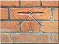
Ordnance Survey Cut Mark with Bolt
This can be found on the roadside wall of a former Chapel building in The Street, Boughton Street.
For more detail see : http://www.bench-marks.org.uk/bm29610
Image: © Peter Wood
Taken: 18 Feb 2016
0.04 miles
4
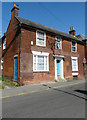
216, The Street
It has a bracket affixed to the frontage, which made me wonder if the house served another purpose in the past.
Image: © John Baker
Taken: 9 Apr 2017
0.04 miles
5
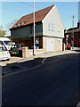
184a, The Street
See Image, which shows the house during its construction.
Image: © John Baker
Taken: 25 Feb 2018
0.04 miles
6
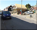
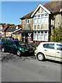
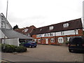
Erection of a dwelling, 184?186, The Street
Planning permission was granted by Swale Borough Council under application number 16/505747/FULL for the “demolition of existing garage and front boundary wall, removal of existing ash tree and erection of a one bedroom dwelling with integral garage and associated external works as amended by drawings received on 27 September 2016”. The building, behind the parked car, is public toilets. This is the same house, described as Image, seen from the SW.
Image: © John Baker
Taken: 9 Apr 2017
0.04 miles
7
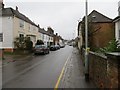
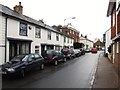
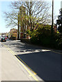
The Street in Boughton Street
Looking eastward.
Image: © Peter Wood
Taken: 18 Feb 2016
0.05 miles
8
Erection of a dwelling, 184?186, The Street
Planning permission was granted by Swale Borough Council under application number 16/505747/FULL for the “demolition of existing garage and front boundary wall, removal of existing ash tree and erection of a one bedroom dwelling with integral garage and associated external works as amended by drawings received on 27 September 2016”. This is the same house, described as Image, seen from the SSE.
Image: © John Baker
Taken: 9 Apr 2017
0.05 miles
9
Old Bakery Mews, Broughton Street
The OS map says Broughton Street while the A-Z says Boughton-under-Blean. I will go with the OS map as these are posted on it but mention the other for reference.
Image: © David Howard
Taken: 19 Jun 2016
0.05 miles
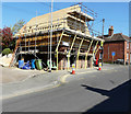
10
Former Wesleyan chapel, The Street
Bill Henderson photographed the Image from the front but I decided I could obtain a better photograph from further away. The building, now converted into apartments, dates from 1844.
Image: © John Baker
Taken: 9 Apr 2017
0.05 miles