IMAGES TAKEN NEAR TO
Tettenhall Way, FAVERSHAM, ME13 8ZA
Introduction
This page details the photographs taken nearby to Tettenhall Way, ME13 8ZA by members of the Geograph project.
The Geograph project started in 2005 with the aim of publishing, organising and preserving representative images for every square kilometre of Great Britain, Ireland and the Isle of Man.

There are currently over 7.5m images from over14,400 individuals and you can help contribute to the project by visiting https://www.geograph.org.uk
Image Map
Images are licensed for reuse under creativecommons.org/licenses/by-sa/2.0
Notes
- Clicking on the map will re-center to the selected point.
- The higher the marker number, the further away the image location is from the centre of the postcode.
Image Listing (26 Images Found)
Images are licensed for reuse under creativecommons.org/licenses/by-sa/2.0
Image
Details
Distance
1
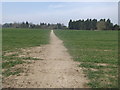
Footpath to Brogdale Road
This field path leads from the A2 London Road (via an access road through Abbey School) and past Perry Court.
Image: © David Anstiss
Taken: 29 Mar 2014
0.03 miles
2
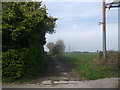
Bridleway to Ospringe
This track leads from Brogdale Road towards Vicarage Lane near Queen Court Farm.
Image: © David Anstiss
Taken: 29 Mar 2014
0.13 miles
3
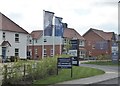
New housing development Faversham
There are large developments on both sides of Brogdale Road. This one, on the east side, is called Perry Court by David Wilson and Barratt Homes.
Image: © pam fray
Taken: 19 Apr 2020
0.15 miles
4
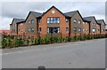
New housing in Tettenhall Way, Faversham, Kent
New housing at the southern end of Tettenhall Way.
Image: © P L Chadwick
Taken: 24 Jul 2023
0.16 miles
5
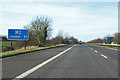
M2 - 51 miles to London
Just after junction 6.
Image: © Robin Webster
Taken: 30 Jan 2018
0.17 miles
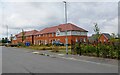
6
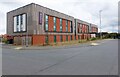
Canterbury House care home, Tettenhall Way, Faversham, Kent
This care home for the elderly, particularly those with dementia, is one of several run by Halcyon Care Homes.
Image: © P L Chadwick
Taken: 24 Jul 2023
0.17 miles
7
Premier Inn (2), Tettenhall Way, Faversham, Kent
Side and back view of this fairly new Premier Inn near Ashford Road (A251).
Image
Image: © P L Chadwick
Taken: 24 Jul 2023
0.20 miles
8
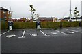
Electric car charging points
Electric car charging points in the Faversham Premier Inn hotel car park.
Image: © Philip Halling
Taken: 20 Oct 2022
0.20 miles
9
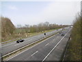
M2 Motorway near Faversham
This section of the M2 opened in 1965 - see https://en.wikipedia.org/wiki/M2_motorway_(Great_Britain) It is seen here from the bridge carrying Brogdale Road over the motorway.
Brogdale is famous for recording the highest ever temperature in the United Kingdom on 10th August 2003 of 38.5 degrees centigrade or 100.58 degrees farenheit.
Image: © Marathon
Taken: 2 Apr 2016
0.20 miles
10
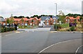
Looking towards Jupiter Grove, Faversham, Kent
Looking towards new housing in Jupiter Grove from Tettenhall Way. On the immediate right is the entrance to Premier Inn.
Image: © P L Chadwick
Taken: 24 Jul 2023
0.21 miles