IMAGES TAKEN NEAR TO
Ashford Road, FAVERSHAM, ME13 8XJ
Introduction
This page details the photographs taken nearby to Ashford Road, ME13 8XJ by members of the Geograph project.
The Geograph project started in 2005 with the aim of publishing, organising and preserving representative images for every square kilometre of Great Britain, Ireland and the Isle of Man.

There are currently over 7.5m images from over14,400 individuals and you can help contribute to the project by visiting https://www.geograph.org.uk
Image Map
Images are licensed for reuse under creativecommons.org/licenses/by-sa/2.0
Notes
- Clicking on the map will re-center to the selected point.
- The higher the marker number, the further away the image location is from the centre of the postcode.
Image Listing (164 Images Found)
Images are licensed for reuse under creativecommons.org/licenses/by-sa/2.0
Image
Details
Distance
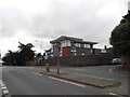
5
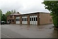
Faversham fire station
Faversham fire station, Ashford Road, Faversham, Kent
Image: © Kevin Hale
Taken: 27 Apr 2009
0.06 miles
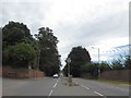
6
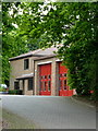
Faversham fire station
Situated off Ashford Road in Beaumont Davy Close, to the east of The Abbey School playing fields.
Image: © pam fray
Taken: 25 May 2015
0.06 miles
7

Crown and Anchor, Pub Sign, Faversham
On Image
Image: © David Anstiss
Taken: 22 Aug 2010
0.11 miles
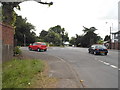
9
Forbes Road at the junction of London Road
Image: © David Howard
Taken: 19 Jun 2016
0.11 miles
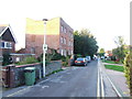
10
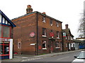
The Crown and Anchor Public House, Faversham
On junction of B2041 The Mall (on right) and Nelson Street (on left).
Image: © David Anstiss
Taken: 10 Apr 2009
0.11 miles