IMAGES TAKEN NEAR TO
Sheerways, FAVERSHAM, ME13 8TP
Introduction
This page details the photographs taken nearby to Sheerways, ME13 8TP by members of the Geograph project.
The Geograph project started in 2005 with the aim of publishing, organising and preserving representative images for every square kilometre of Great Britain, Ireland and the Isle of Man.

There are currently over 7.5m images from over14,400 individuals and you can help contribute to the project by visiting https://www.geograph.org.uk
Image Map
Images are licensed for reuse under creativecommons.org/licenses/by-sa/2.0
Notes
- Clicking on the map will re-center to the selected point.
- The higher the marker number, the further away the image location is from the centre of the postcode.
Image Listing (100 Images Found)
Images are licensed for reuse under creativecommons.org/licenses/by-sa/2.0
Image
Details
Distance
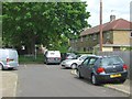
1
![Ospringe houses [16]](https://s3.geograph.org.uk/geophotos/07/05/77/7057723_f7b79b9a_120x120.jpg)
Ospringe houses [16]
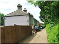
Even numbers 50 to 60 Ospringe Street are in two groups. Numbers 50 and 52 are a pair of early 19th century houses in painted brick under a tile roof. Numbers 54, 56, 58 and 60 are a row of early 19th century houses in brick, with various finishes, under a tile roof. Listed, grade II, with details at: https://historicengland.org.uk/listing/the-list/list-entry/1320245
Ospringe is a village and area of Faversham, Kent. The village lies on the Roman road Watling Street (now the A2). The historic Maison Dieu fronts onto Watling Street and the remains of substantial Roman buildings, thought to be the site of the Durolevum mentioned in the Antonine Itinerary, have been found nearby.
Image: © Michael Dibb
Taken: 5 Sep 2021
0.05 miles
2
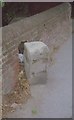
Old Milestone by the A2, Ospringe Street, Faversham
Stone post (plates lost) by the A2, in parish of Faversham (Swale District), Ospringe Street, West of junction with Sheerways, in pavement back to brick boundary wall, on North side of road. Dover Road facet, erected by the Chatham & Canterbury turnpike trust in the 19th century.
Inscription once read:-
: (To / Canterbury / 9 Miles) : : (To / London / 46 / Miles) :
Kent HER.
HER Number: TR 06 SW 276 https://www.heritagegateway.org.uk/Gateway/Results_Single.aspx?uid=MKE77988&resourceID=1005
Milestone Society National ID: KE_LD46
Image: © C Woodward
Taken: 5 Jun 2007
0.05 miles
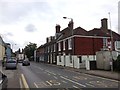
6
![Ospringe houses [19]](https://s2.geograph.org.uk/geophotos/07/05/77/7057726_8885b849_120x120.jpg)
Ospringe houses [19]
Lion Lodge, number 67 Ospringe Street, was built in the 18th century. Constructed of brick with the ground floor in roughcast and the first floor tile hung, all under a tile roof. Listed, grade II, with details at: https://historicengland.org.uk/listing/the-list/list-entry/1320242
Ospringe is a village and area of Faversham, Kent. The village lies on the Roman road Watling Street (now the A2). The historic Maison Dieu fronts onto Watling Street and the remains of substantial Roman buildings, thought to be the site of the Durolevum mentioned in the Antonine Itinerary, have been found nearby.
Image: © Michael Dibb
Taken: 5 Sep 2021
0.06 miles
7
![Ospringe houses [18]](https://s1.geograph.org.uk/geophotos/07/05/77/7057725_29c3ff40_120x120.jpg)
Ospringe houses [18]
Poulders, number 65 Ospringe Street, was built in the early 19th century. Constructed of painted brick under a tile roof. Listed, grade II, with details at: https://historicengland.org.uk/listing/the-list/list-entry/1069434
Ospringe is a village and area of Faversham, Kent. The village lies on the Roman road Watling Street (now the A2). The historic Maison Dieu fronts onto Watling Street and the remains of substantial Roman buildings, thought to be the site of the Durolevum mentioned in the Antonine Itinerary, have been found nearby.
Image: © Michael Dibb
Taken: 5 Sep 2021
0.06 miles
8
![Ospringe houses [17]](https://s0.geograph.org.uk/geophotos/07/05/77/7057724_a8bc7810_120x120.jpg)
Ospringe houses [17]
Number 59 Ospringe Street, was built in the 18th century. Constructed of painted brick under a hipped tile roof behind a parapet. Listed, grade II, with details at: https://historicengland.org.uk/listing/the-list/list-entry/1069433
Ospringe is a village and area of Faversham, Kent. The village lies on the Roman road Watling Street (now the A2). The historic Maison Dieu fronts onto Watling Street and the remains of substantial Roman buildings, thought to be the site of the Durolevum mentioned in the Antonine Itinerary, have been found nearby.
Image: © Michael Dibb
Taken: 5 Sep 2021
0.07 miles