IMAGES TAKEN NEAR TO
Canterbury Road, FAVERSHAM, ME13 8LR
Introduction
This page details the photographs taken nearby to Canterbury Road, ME13 8LR by members of the Geograph project.
The Geograph project started in 2005 with the aim of publishing, organising and preserving representative images for every square kilometre of Great Britain, Ireland and the Isle of Man.

There are currently over 7.5m images from over14,400 individuals and you can help contribute to the project by visiting https://www.geograph.org.uk
Image Map
Images are licensed for reuse under creativecommons.org/licenses/by-sa/2.0
Notes
- Clicking on the map will re-center to the selected point.
- The higher the marker number, the further away the image location is from the centre of the postcode.
Image Listing (123 Images Found)
Images are licensed for reuse under creativecommons.org/licenses/by-sa/2.0
Image
Details
Distance
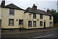
3
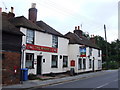
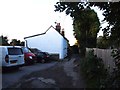
The former Windmill public house, Canterbury Road
Planning permission has been granted by Swale Borough Council under application number SW/11/1582 for “change of use from a public house to two residential dwellings, extensions, internal alterations and changes to fenestration". This shows how the building appeared as Image and how the house to its right has been repainted!
Image: © John Baker
Taken: 1 Sep 2013
0.01 miles
4
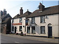
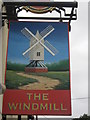
The Windmill Public House, Faversham
On A2 Canterbury Road in an area of houses called 'Preston Village'
Image: © David Anstiss
Taken: 2 Jul 2009
0.01 miles
6
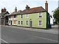
Able Antiques, The Old Forge, Canterbury Road
The windows have been boarded up but the white strip over the door provided the name of the business.
Image: © John Baker
Taken: 1 Sep 2013
0.02 miles
7
Ex Windmill Public House
Grade II listed. http://www.britishlistedbuildings.co.uk/en-438906-the-windmill-public-house-faversham
Image: © N Chadwick
Taken: 5 Jul 2011
0.02 miles
8
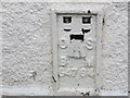
Ordnance Survey Flush Bracket G4764
This can be found on the wall of a building at Kent Council, Faversham Highways Depot in Cantrbury Road.
For more detail see : http://www.bench-marks.org.uk/bm16134
Image: © Peter Wood
Taken: 18 Feb 2016
0.02 miles
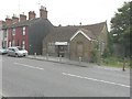
10

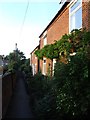
Preston Lane footpath
This footpath leads from the A2 Canterbury Road towards St.Catherines Church near Faversham Railway station.
Image: © David Anstiss
Taken: 22 Aug 2010
0.02 miles