IMAGES TAKEN NEAR TO
East Street, FAVERSHAM, ME13 8AY
Introduction
This page details the photographs taken nearby to East Street, ME13 8AY by members of the Geograph project.
The Geograph project started in 2005 with the aim of publishing, organising and preserving representative images for every square kilometre of Great Britain, Ireland and the Isle of Man.

There are currently over 7.5m images from over14,400 individuals and you can help contribute to the project by visiting https://www.geograph.org.uk
Image Map
Images are licensed for reuse under creativecommons.org/licenses/by-sa/2.0
Notes
- Clicking on the map will re-center to the selected point.
- The higher the marker number, the further away the image location is from the centre of the postcode.
Image Listing (468 Images Found)
Images are licensed for reuse under creativecommons.org/licenses/by-sa/2.0
Image
Details
Distance
1
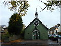
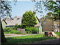
The "tin church", once St. Saviour's
Now a private residence and art studio, it is open to the public this weekend to show an exhibition of art and craft as part of the Canterbury Festival. It is on Whitstable Road between Orchard Place and Cyprus Road, which can be seen to the right of the picture.
Image: © pam fray
Taken: 31 Oct 2010
0.01 miles
2
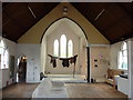
Inside the converted church, known as the tin church
Now a private residence,this is the studio area, at present showing exhibits of art and crafts as part of the Canterbury Festival. The living area is through the door on the left.
Image: © pam fray
Taken: 31 Oct 2010
0.01 miles
3
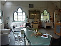
The living area in the converted "tin church", once St. Saviour's
The building has been open to the public to display exhibits of art and craft as part of the Canterbury Festival. This room leads off the main studio where the work is on show.
Image: © pam fray
Taken: 31 Oct 2010
0.01 miles
4
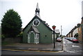
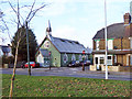
Church of St Savoir
Grade II listed https://historicengland.org.uk/listing/the-list/list-entry/1240313
Now a café.
Image: © Oast House Archive
Taken: 19 Apr 2019
0.02 miles
5
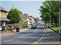
Whitstable Road
B2040 road leading out of Faversham.
Image: © Oast House Archive
Taken: 25 Apr 2011
0.03 miles
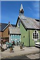
6
St Saviour's Church, Faversham
Corrugated church building at corner of Cyprus Road and Whitstable Road.
Image: © Oast House Archive
Taken: 25 Apr 2011
0.03 miles
8
A tin chapel
In fact it is a church, St. Saviour's, and grade II listed as an unusually elaborate and complete survival of the type. Built in 1885. A prefabricated tin church of elaborate design built as one of two mission churches under the auspices of the Parish Church of St Mary of Charity. It does not appear to be used as a church now.
Image: © Robin Webster
Taken: 9 Feb 2014
0.03 miles
9
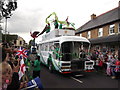
Lloyds TSB Bank Promotional lorry, Day 62 Olympic Torch Relay
This is one of three lorries ahead of the torch runner, coming along Whitstable Road towards the centre of Faversham.
In the far background is Image
In the foreground is a girl (one of many children) blowing a loud annoying whistle.
Image: © David Anstiss
Taken: 19 Jul 2012
0.03 miles
10
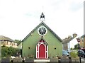
Tin church, Whitstable Road, Faversham
This was, originally, St. Saviour's Church, built in 1886. The 19th century saw a rapid growth in urban population, resulting in a widespread call for new churches and chapels, often referred to as ‘tin tabernacles’. They were designed and made in kit form, to be bought from illustrated catalogues. Timber framed and externally clad with galvanised corrugated iron, the ‘flat pack’ churches were easy to erect and transport, and were light, strong and relatively inexpensive compared to conventional building materials. The church was de-consecrated in 1951 and has been put to various uses, including a joinery shop, a gymnasium and a private house. In 2018 it became The Hot Tin, a cafe, bar, music and arts venue. Cyprus Road is on the right.
Image: © pam fray
Taken: 5 Sep 2020
0.03 miles