IMAGES TAKEN NEAR TO
Narboths Nursery, Canterbury Road, FAVERSHAM, ME13 8AX
Introduction
This page details the photographs taken nearby to Narboths Nursery, Canterbury Road, ME13 8AX by members of the Geograph project.
The Geograph project started in 2005 with the aim of publishing, organising and preserving representative images for every square kilometre of Great Britain, Ireland and the Isle of Man.

There are currently over 7.5m images from over14,400 individuals and you can help contribute to the project by visiting https://www.geograph.org.uk
Image Map
Images are licensed for reuse under creativecommons.org/licenses/by-sa/2.0
Notes
- Clicking on the map will re-center to the selected point.
- The higher the marker number, the further away the image location is from the centre of the postcode.
Image Listing (77 Images Found)
Images are licensed for reuse under creativecommons.org/licenses/by-sa/2.0
Image
Details
Distance
6
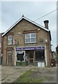
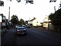
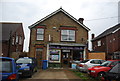
Macknade Stores, Faversham
On Canterbury Road (the A2), this general store and post office has sadly closed and is in a state of disrepair.
Image: © pam fray
Taken: 3 May 2020
0.07 miles