IMAGES TAKEN NEAR TO
Church Road, FAVERSHAM, ME13 8AW
Introduction
This page details the photographs taken nearby to Church Road, ME13 8AW by members of the Geograph project.
The Geograph project started in 2005 with the aim of publishing, organising and preserving representative images for every square kilometre of Great Britain, Ireland and the Isle of Man.

There are currently over 7.5m images from over14,400 individuals and you can help contribute to the project by visiting https://www.geograph.org.uk
Image Map
Images are licensed for reuse under creativecommons.org/licenses/by-sa/2.0
Notes
- Clicking on the map will re-center to the selected point.
- The higher the marker number, the further away the image location is from the centre of the postcode.
Image Listing (1124 Images Found)
Images are licensed for reuse under creativecommons.org/licenses/by-sa/2.0
Image
Details
Distance
1
Flint House, Faversham
Seen from Church Road. Close to St Mary's Court (converted church). Modern building on the left is Plane Tree House.
Image: © David Anstiss
Taken: 3 Oct 2009
0.00 miles
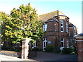
2
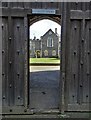
Entrance to St Mary Court, Faversham
St Mary Court is now the location of several residences but it was once a school campus.
Image: © Neil Theasby
Taken: 25 Mar 2019
0.03 miles
3
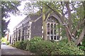
St Mary's Court, Faversham
Seen from Church Road. This former church has been converted into various flats.
Image: © David Anstiss
Taken: 3 Oct 2009
0.04 miles
4
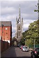
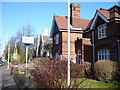
Church Road, Faversham
This short road leads from East Street towards St Mary of Charity Church. The large building on the left is part of the converted Fremlins Brewery Building (closed in 1990). The main part of the brewery is now Tesco Supermarket, this was converted in 1996. There is a pedestrian access to the supermarket, further along the road.
Image: © David Anstiss
Taken: 3 Oct 2009
0.04 miles
5
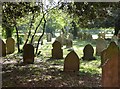
St. Mary's churchyard, Faversham
Early sunshine through the gravestones.
Image: © pam fray
Taken: 23 Apr 2020
0.04 miles
7
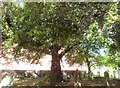
Ash tree in the churchyard of St. Mary's church, Faversham
An enormous, mature tree growing near the edge of the churchyard with the wall of Tesco supermarket behind.
Image: © pam fray
Taken: 13 Jun 2020
0.05 miles
8
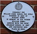
Plaque on William Gibbs School, Faversham
This is one of the 41 Faversham Society plaques around the historic town.
Image: © David Anstiss
Taken: 29 Sep 2012
0.05 miles
9
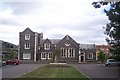
Former William Gibbs School, Faversham
This large red-brick Grade II listed building on Orchard Place, was once a school built by Richard Gibbs, a tea planter, and named in honour of his brother William Gibbs a local amateur archaeologist. See http://www.britishlistedbuildings.co.uk/en-438703-former-william-gibbs-school-faversham-ke for more details about the building.
It was later converted into a block of flats.
On the side of the building is Image One of the 42 Faversham Society plaques.
Image: © David Anstiss
Taken: 29 Sep 2012
0.05 miles
10

St. Mary's churchyard, Faversham
St. Mary's church is, like all churches, closed during the coronavirus pandemic and the churchyard is inaccessible apart from peering over railings.
Image: © pam fray
Taken: 8 Apr 2020
0.05 miles