IMAGES TAKEN NEAR TO
Hollow Shore, FAVERSHAM, ME13 7TU
Introduction
This page details the photographs taken nearby to Hollow Shore, ME13 7TU by members of the Geograph project.
The Geograph project started in 2005 with the aim of publishing, organising and preserving representative images for every square kilometre of Great Britain, Ireland and the Isle of Man.

There are currently over 7.5m images from over14,400 individuals and you can help contribute to the project by visiting https://www.geograph.org.uk
Image Map
Images are licensed for reuse under creativecommons.org/licenses/by-sa/2.0
Notes
- Clicking on the map will re-center to the selected point.
- The higher the marker number, the further away the image location is from the centre of the postcode.
Image Listing (172 Images Found)
Images are licensed for reuse under creativecommons.org/licenses/by-sa/2.0
Image
Details
Distance
1
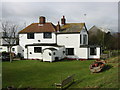
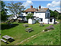
The Shipwrights Arms at Oare
Remote pub with wonderful views
Image: © Rod Bacon
Taken: 24 Feb 2009
0.01 miles
2
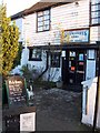
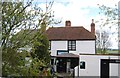
Shipwrights Arms Public House
At Hollowshore, near Oare. End of Ham Road.
Small boatyard around the pub, but also popular by Faversham locals as well.
Image: © David Anstiss
Taken: 1 Jan 2003
0.02 miles
4
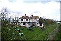
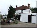
The Shipwrights Arms from the Saxon Shore Way
The Shipwrights Arms is right next to the riverbank at the point where Faversham Creek and Oare Creek meet before continuing out to The Swale. It is reached from Oare via Ham Road. There are a number of boat yards at this otherwise remote spot and the riverbank is followed by the Two Creeks Walk and the Saxon Shore Way.
See http://www.faversham.org/upload/docs/two%20creeks%20leaflet%20FINAL.pdf for more information about and details of the Two Creeks Walk.
Image: © Marathon
Taken: 6 Jun 2015
0.02 miles
5

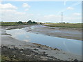
Hollow Shore from the Harty Ferry Road
The buildings (which include the Shipwrights Arms) seen through the feet of the pylon are at Hollow Shore, the confluence of Oare Creek with Faversham Creek. I notice that Hollow Shore appears as Holly Shore on the 19th century map but I suspect this is a cartographer error.
Image: © Penny Mayes
Taken: 9 Apr 2007
0.02 miles
6
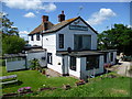
The Shipwrights Arms from the Saxon Shore Way
The Shipwrights Arms is right next to the riverbank at the point where Faversham Creek and Oare Creek meet before continuing out to The Swale. It is reached from Oare via Ham Road. There are a number of boat yards at this otherwise remote spot and the riverbank is followed by the Two Creeks Walk and the Saxon Shore Way.
See http://www.faversham.org/upload/docs/two%20creeks%20leaflet%20FINAL.pdf for more information about and details of the Two Creeks Walk.
Image: © Marathon
Taken: 6 Jun 2015
0.03 miles
7
Shipwrights Arms
Pub at the junction of Oare Creek and Faversham Creek.
Image: © N Chadwick
Taken: 22 Apr 2012
0.03 miles
9
Approaching the Shipwrights Arms
This is where Faversham Creek meets Oare Creek and travels northwards to The Swale.
Image: © pam fray
Taken: 14 Jun 2009
0.03 miles
10
The Shipwrights Arms public house, Oare
Sadly temporarily closed, like all similar places during lockdown.
Image: © pam fray
Taken: 15 Feb 2021
0.03 miles