
IMAGES TAKEN NEAR TO
Willement Road, FAVERSHAM, ME13 7SY
Introduction
This page details the photographs taken nearby to Willement Road, ME13 7SY by members of the Geograph project.
The Geograph project started in 2005 with the aim of publishing, organising and preserving representative images for every square kilometre of Great Britain, Ireland and the Isle of Man.

There are currently over 7.5m images from over14,400 individuals and you can help contribute to the project by visiting https://www.geograph.org.uk
Image Map
Images are licensed for reuse under creativecommons.org/licenses/by-sa/2.0
Notes
- Clicking on the map will re-center to the selected point.
- The higher the marker number, the further away the image location is from the centre of the postcode.
Image Listing (149 Images Found)
Images are licensed for reuse under creativecommons.org/licenses/by-sa/2.0
Image
Details
Distance
1
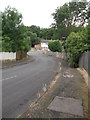
Penshurst Rise, Davington
This road leads down from Willament Road towards The Knole.
It used to be open to traffic when I used to cycle to school (in the 80/90's).
But nowadays a metal barrier stops cars going up or down the hill.
Beyond the Knole is Knole Wood (a protected local nature reserve).
Image: © David Anstiss
Taken: 16 Jul 2012
0.04 miles
2
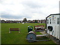
Davington Priory Cricket Club ground
Viewed from the clubhouse on Greenway and looking across to Alexander Drive and Old Gate Road.
Image: © pam fray
Taken: 24 Sep 2008
0.08 miles
3
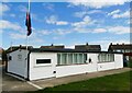
Davington Priory Cricket Club pavilion
11 Greenway, Faversham. Their flag flies at half-mast on the day of Queen Eizabeth II's funeral.
Image: © pam fray
Taken: 19 Sep 2022
0.10 miles
4
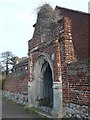
The old gate in Old Gate Road
Plaque reads"....built in 1624 in mannerist style, gave access to the garden of Davington Court, an ancient manor house." This is all that remains on what is now a modern housing estate.
Image: © pam fray
Taken: 13 Jan 2008
0.11 miles
5
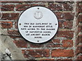
The Old Gate Plaque, Davington Court, Faversham
This is a close-up of the plaque on Image
One of the 41 plaques around the historic town.
Image: © David Anstiss
Taken: 16 Jul 2012
0.12 miles
6
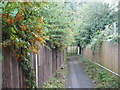
Footpath from Alexander Drive to the foot of Dark Hill, Davington
Image: © pam fray
Taken: 24 Sep 2008
0.12 miles
7

Winter heliotrope, Faversham
Growing by the stream near The Knole. Petasites fragrans is an invasive, non-native plant that grows near water and blooms from January.
Image: © pam fray
Taken: 22 Feb 2022
0.12 miles
8
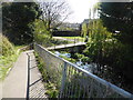
Bridge and footpath from The Knoll, Faversham
The bridge crosses the stream to the footpath.
Image: © pam fray
Taken: 30 Mar 2020
0.12 miles
9
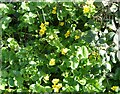
Marsh marigolds, Faversham
Blooming early in the stream near The Knole. Caltha palustris is also known as kingcup.
Image: © pam fray
Taken: 22 Feb 2022
0.12 miles
10

Marsh marigolds, Faversham
Blooming early in the stream near The Knole. Caltha palustris is also known as kingcup.
Image: © pam fray
Taken: 22 Feb 2022
0.12 miles