IMAGES TAKEN NEAR TO
St. Nicholas Road, FAVERSHAM, ME13 7PG
Introduction
This page details the photographs taken nearby to St. Nicholas Road, ME13 7PG by members of the Geograph project.
The Geograph project started in 2005 with the aim of publishing, organising and preserving representative images for every square kilometre of Great Britain, Ireland and the Isle of Man.

There are currently over 7.5m images from over14,400 individuals and you can help contribute to the project by visiting https://www.geograph.org.uk
Image Map
Images are licensed for reuse under creativecommons.org/licenses/by-sa/2.0
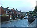
Notes
- Clicking on the map will re-center to the selected point.
- The higher the marker number, the further away the image location is from the centre of the postcode.
Image Listing (101 Images Found)
Images are licensed for reuse under creativecommons.org/licenses/by-sa/2.0
Image
Details
Distance
5
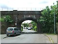
Railway Bridge over Wallers Road and Grove Place, Ospringe
Image: © Chris Whippet
Taken: 24 May 2015
0.07 miles
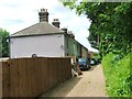
6
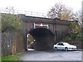
Railway bridge over Grove Place Road
Railway travels from Sittingbourne/London on right, towards Faversham and then Dover/Ramsgate on the left. Grove Place is a one-way road from Ospringe Street (A2) into Ospringe/Faversham.
Image: © David Anstiss
Taken: 8 Nov 2008
0.08 miles
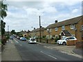
7
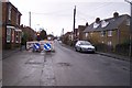
Roadworks on Lower Road, Faversham
Lower Road leads from Ospringe Road to various closes to the west of Faversham.
The road works are due to the replacement of a gas main along the road. There have been works along this road, all this year.
Image: © David Anstiss
Taken: 9 Dec 2009
0.08 miles
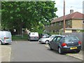
8
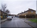
Junction on St Nicholas Road
St Nicholas Road leads from Wellers Road to Bensted Grove. On the right is Roebuck Road leading to Lower Road.
Image: © David Anstiss
Taken: 17 Jan 2010
0.08 miles
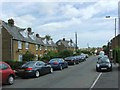
10
![Ospringe houses [16]](https://s3.geograph.org.uk/geophotos/07/05/77/7057723_f7b79b9a_120x120.jpg)
Ospringe houses [16]
Even numbers 50 to 60 Ospringe Street are in two groups. Numbers 50 and 52 are a pair of early 19th century houses in painted brick under a tile roof. Numbers 54, 56, 58 and 60 are a row of early 19th century houses in brick, with various finishes, under a tile roof. Listed, grade II, with details at: https://historicengland.org.uk/listing/the-list/list-entry/1320245
Ospringe is a village and area of Faversham, Kent. The village lies on the Roman road Watling Street (now the A2). The historic Maison Dieu fronts onto Watling Street and the remains of substantial Roman buildings, thought to be the site of the Durolevum mentioned in the Antonine Itinerary, have been found nearby.
Image: © Michael Dibb
Taken: 5 Sep 2021
0.09 miles