IMAGES TAKEN NEAR TO
Ospringe Road, FAVERSHAM, ME13 7LH
Introduction
This page details the photographs taken nearby to Ospringe Road, ME13 7LH by members of the Geograph project.
The Geograph project started in 2005 with the aim of publishing, organising and preserving representative images for every square kilometre of Great Britain, Ireland and the Isle of Man.

There are currently over 7.5m images from over14,400 individuals and you can help contribute to the project by visiting https://www.geograph.org.uk
Image Map
Images are licensed for reuse under creativecommons.org/licenses/by-sa/2.0
Notes
- Clicking on the map will re-center to the selected point.
- The higher the marker number, the further away the image location is from the centre of the postcode.
Image Listing (105 Images Found)
Images are licensed for reuse under creativecommons.org/licenses/by-sa/2.0
Image
Details
Distance
2
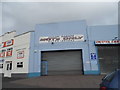
Ospringe Fish Bar, Ospringe Road, Faversham
A popular venue for fish and chips and other takeaway foods.
Image: © pam fray
Taken: 11 Jul 2016
0.03 miles
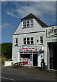
4
![Ospringe buildings [1]](https://s1.geograph.org.uk/geophotos/07/05/77/7057709_41667104_120x120.jpg)
Ospringe buildings [1]
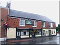
The Ship Inn, number 12 Ospringe Street, was built in the 18th century. Constructed of red brick under a tile roof. Listed, grade II, with details at: https://historicengland.org.uk/listing/the-list/list-entry/1343870
Ospringe is a village and area of Faversham, Kent. The village lies on the Roman road Watling Street (now the A2). The historic Maison Dieu fronts onto Watling Street and the remains of substantial Roman buildings, thought to be the site of the Durolevum mentioned in the Antonine Itinerary, have been found nearby.
Image: © Michael Dibb
Taken: 5 Sep 2021
0.05 miles
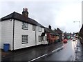
5
![Ospringe houses [7]](https://s3.geograph.org.uk/geophotos/07/05/67/7056743_0167d192_120x120.jpg)
Ospringe houses [7]
Number 5 Ospringe Street (seen here) and numbers 7 and 9 Ospringe Street Image, are a range of, originally, five cottages, now three cottages. Built in the 18th century of brick (numbers 5 and 9 painted, number 7 stuccoed) under a tile roof. The ground floor of number 5 has been rebuilt with a 19th century bow window. Listed, grade II, with details at: https://historicengland.org.uk/listing/the-list/list-entry/1069428
Ospringe is a village and area of Faversham, Kent. The village lies on the Roman road Watling Street (now the A2). The historic Maison Dieu fronts onto Watling Street and the remains of substantial Roman buildings, thought to be the site of the Durolevum mentioned in the Antonine Itinerary, have been found nearby.
Image: © Michael Dibb
Taken: 5 Sep 2021
0.05 miles
6
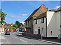
The A2 at Ospringe
Up until about 1970 this road - narrow as it is - was the main London-Dover road. This stretch has since been supplanted by the M2, while the stretch from the Medway to London has been repeatedly upgraded, retaining the A2 designation - but there the resemblance ends: http://www.geograph.org.uk/photo/1556402
In this shot the building with the overhanging first floor is part of the old Maison Dieu. The flint-built lower portions date back to the 13th century (when the place was a Knights Templars' hospital) while the timber-framed upper storey is reckoned to be of 16th century origin. The building now houses a museum. For the listing text see http://www.britishlistedbuildings.co.uk/en-175959-the-maison-dieu-museum-17-faversham
Image: © Stefan Czapski
Taken: 26 Jun 2012
0.05 miles
8
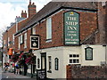
Faversham - 2015
Faversham, Kent, Ospringe, 'The Ship Inn',12 Ospringe Street, London Road, A2
Image: © Helmut Zozmann
Taken: 29 Jul 2015
0.05 miles
9
![Ospringe houses [6]](https://s2.geograph.org.uk/geophotos/07/05/67/7056742_eaf367f5_120x120.jpg)
Ospringe houses [6]
Numbers 1 and 3 Ospringe Street are a pair of 18th century houses. Timber framed on a brick plinth, weatherboarded, all under a tile roof. Listed, grade II, with details at: https://historicengland.org.uk/listing/the-list/list-entry/1069427
Ospringe is a village and area of Faversham, Kent. The village lies on the Roman road Watling Street (now the A2). The historic Maison Dieu fronts onto Watling Street and the remains of substantial Roman buildings, thought to be the site of the Durolevum mentioned in the Antonine Itinerary, have been found nearby.
Image: © Michael Dibb
Taken: 5 Sep 2021
0.05 miles
10
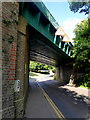
Railway bridge over Ospringe Road, Faversham
The line runs between Teynham and Faversham stations. The bridge has a 4.1 metre height restriction sometimes ignored by drivers of high vehicles with chaotic consequences.
Image: © pam fray
Taken: 11 Jul 2016
0.05 miles