IMAGES TAKEN NEAR TO
Broomfield Road, FAVERSHAM, ME13 7HB
Introduction
This page details the photographs taken nearby to Broomfield Road, ME13 7HB by members of the Geograph project.
The Geograph project started in 2005 with the aim of publishing, organising and preserving representative images for every square kilometre of Great Britain, Ireland and the Isle of Man.

There are currently over 7.5m images from over14,400 individuals and you can help contribute to the project by visiting https://www.geograph.org.uk
Image Map
Images are licensed for reuse under creativecommons.org/licenses/by-sa/2.0
Notes
- Clicking on the map will re-center to the selected point.
- The higher the marker number, the further away the image location is from the centre of the postcode.
Image Listing (310 Images Found)
Images are licensed for reuse under creativecommons.org/licenses/by-sa/2.0
Image
Details
Distance
1
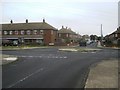
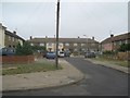
When a roundabout is also a crossroads ???
The junction of Brook Road (with mini roundabout) and Broomfield Road.
Brook Road leads straight on to Springhead Road. Seen from Reedland Crescent.
Image: © David Anstiss
Taken: 31 Jul 2010
0.02 miles
2
Perry's Close, Faversham
This private close leads of Broomfield Road.
Image: © David Anstiss
Taken: 28 May 2011
0.06 miles
3
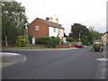
Road junction on Broomfield Road
Broomfield Road leads through the Brents Estate towards Upper Brents (road).
On the left is Crispin Close.
Image: © David Anstiss
Taken: 28 May 2011
0.08 miles
4
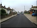
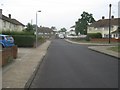
Reedland Crescent (2)
Road in Upper Brents Estate. Heading from Broomfield Road to Barnfield Road.
St Mary Magdalene Church is seen in the background
Image: © David Anstiss
Taken: 31 Jul 2010
0.08 miles
5
Reedland Crescent close
Part of the Upper Brents Estate. Close leading off Reedland Crescent.
Image: © David Anstiss
Taken: 31 Jul 2010
0.08 miles
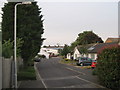
6
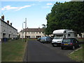
Reedland Crescent
Part of the Upper Brents Estate. This road leads from Broomfield Road to Bramblehill Road.
Image: © David Anstiss
Taken: 31 Jul 2010
0.08 miles
7
Stonedane Court, Faversham
This (three sided) looped road leads of Bramblehill Road.
Image: © David Anstiss
Taken: 31 May 2011
0.10 miles
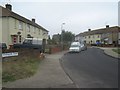
8
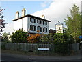
The Brents Tavern, Faversham
Public house of junction of Broomfield Road (on left) and Upper Brents (on right).
Image: © David Anstiss
Taken: 22 Apr 2009
0.10 miles
9
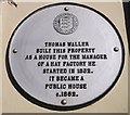
Plaque on Brents Tavern, Faversham
This plaque is one of 42 Faversham Society plaques around the historic town of Faversham.
Image: © David Anstiss
Taken: 29 Sep 2012
0.11 miles
10
Sevenacre Road
Road in Upper Brents Estate. Leading from Reedland Crescent to Barnfield Road.
Image: © David Anstiss
Taken: 31 Jul 2010
0.11 miles