IMAGES TAKEN NEAR TO
Weaver Avenue, FAVERSHAM, ME13 7GW
Introduction
This page details the photographs taken nearby to Weaver Avenue, ME13 7GW by members of the Geograph project.
The Geograph project started in 2005 with the aim of publishing, organising and preserving representative images for every square kilometre of Great Britain, Ireland and the Isle of Man.

There are currently over 7.5m images from over14,400 individuals and you can help contribute to the project by visiting https://www.geograph.org.uk
Image Map
Images are licensed for reuse under creativecommons.org/licenses/by-sa/2.0
Notes
- Clicking on the map will re-center to the selected point.
- The higher the marker number, the further away the image location is from the centre of the postcode.
Image Listing (39 Images Found)
Images are licensed for reuse under creativecommons.org/licenses/by-sa/2.0
Image
Details
Distance
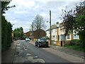
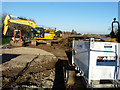
1

Construction of more houses, Faversham
Along Sumpter way.
Image: © David Anstiss
Taken: 8 Nov 2008
0.01 miles
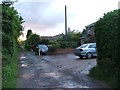
3
Brick Works
On the western edge of Faversham stands this brick works, with housing right up to the gate. It presumably has lorry access from the Western Link Road.
Image: © Penny Mayes
Taken: 9 Apr 2007
0.04 miles
4
Playground on Sumpter Way
Being well used by these youngsters on their Easter holidays.
Image: © Penny Mayes
Taken: 9 Apr 2007
0.06 miles
5
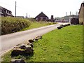
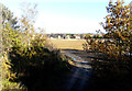
Development land
Planning permission has been granted by Swale Borough Council under application number 14/502729/OUT for “outline (access not reserved) - demolition of brick making and drying shed, 2 stores, existing site office and a cottage; construction of up to 250 dwellings, new vehicular access and roundabout on Western Link, public open space and associated infrastructure”.
The development is to take place on the former Ospringe Brickworks, which were located in Sumpter Way, of which a solitary chimney remains. This is another area of the Image
Image: © John Baker
Taken: 18 Nov 2018
0.06 miles
6
Development land
Planning permission has been granted by Swale Borough Council under application number 14/502729/OUT for “outline (access not reserved) - demolition of brick making and drying shed, 2 stores, existing site office and a cottage; construction of up to 250 dwellings, new vehicular access and roundabout on Western Link, public open space and associated infrastructure”.
The development is to take place on the former Ospringe Brickworks, which were located in Sumpter Way, of which a solitary chimney remains.
This is another area of the Image
Image: © John Baker
Taken: 18 Nov 2018
0.07 miles
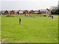
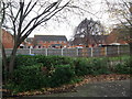
7
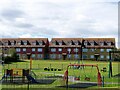
Play area and recreation ground, Faversham
Viewed from Lower Road.
Image: © pam fray
Taken: 19 Sep 2022
0.09 miles
8
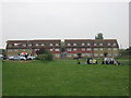
Street Party near Bensted Grove
This recreational ground (beside Lower Road) is being used for an informal street party / gathering.
Under the red and white canopy (on the left) is a stereo system providing music.
Houses on Bensted Grove are in the background.
Image: © David Anstiss
Taken: 29 Apr 2011
0.10 miles
9
View of Lewis Close, Faversham
As seen from Kiln Court.
Image: © David Anstiss
Taken: 25 Dec 2011
0.10 miles