IMAGES TAKEN NEAR TO
Goldfinch Close, FAVERSHAM, ME13 7EP
Introduction
This page details the photographs taken nearby to Goldfinch Close, ME13 7EP by members of the Geograph project.
The Geograph project started in 2005 with the aim of publishing, organising and preserving representative images for every square kilometre of Great Britain, Ireland and the Isle of Man.

There are currently over 7.5m images from over14,400 individuals and you can help contribute to the project by visiting https://www.geograph.org.uk
Image Map
Images are licensed for reuse under creativecommons.org/licenses/by-sa/2.0
Notes
- Clicking on the map will re-center to the selected point.
- The higher the marker number, the further away the image location is from the centre of the postcode.
Image Listing (53 Images Found)
Images are licensed for reuse under creativecommons.org/licenses/by-sa/2.0
Image
Details
Distance
1
Ham Road, Davington, Faversham
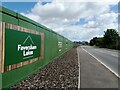
Faversham Lakes is an ongoing large housing development on Ham Road.
Image: © pam fray
Taken: 10 Jun 2022
0.04 miles
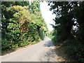
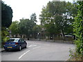
2
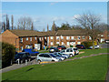
Goldfinch Close
One branch of the several branches of the close.
Image: © Robin Webster
Taken: 9 Feb 2014
0.04 miles
3
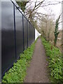
Footpath, Faversham
Leading to Fostall Road. The fencing on the left seals off a site for housing development.
Image: © pam fray
Taken: 17 Mar 2021
0.04 miles
4
Goldfinch Close
A much branched residential road.
Image: © Robin Webster
Taken: 9 Feb 2014
0.04 miles

6
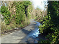
Ham Road, 2014
A view much changed because of housing development. This part of the lane has been eliminated and a diversion made over to the left to a new junction with Oare Road.
Image: © Robin Webster
Taken: 9 Feb 2014
0.08 miles
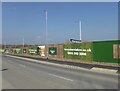
8
Evers Road, Faversham
A new road on part of a large housing development in progress off Ham Road, named Faversham Lakes. This former wartime gunpowder factory and, subsequently, gravel works will provide 330 new homes, a country park and a heritage educational hub, built on the 131 acre sit on the edge of the town bordering on the village of Oare.
Image: © pam fray
Taken: 24 Feb 2021
0.11 miles
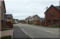
9
Ham Road, Faversham
Once a quiet lane on the edge of town, now in part a large development of houses extending, in some places, on both sides of the road. The lake referred to in the title of the development is the gravel works.
Image: © pam fray
Taken: 27 Mar 2020
0.11 miles
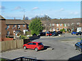
10
The junction of Ham Road with Priory Row
Davington Primary School in Priory Row can be seen opposite.
Image: © pam fray
Taken: 14 Jun 2009
0.11 miles