IMAGES TAKEN NEAR TO
Russell Place, FAVERSHAM, ME13 0QF
Introduction
This page details the photographs taken nearby to Russell Place, ME13 0QF by members of the Geograph project.
The Geograph project started in 2005 with the aim of publishing, organising and preserving representative images for every square kilometre of Great Britain, Ireland and the Isle of Man.

There are currently over 7.5m images from over14,400 individuals and you can help contribute to the project by visiting https://www.geograph.org.uk
Image Map
Images are licensed for reuse under creativecommons.org/licenses/by-sa/2.0
Notes
- Clicking on the map will re-center to the selected point.
- The higher the marker number, the further away the image location is from the centre of the postcode.
Image Listing (269 Images Found)
Images are licensed for reuse under creativecommons.org/licenses/by-sa/2.0
Image
Details
Distance
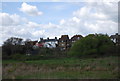
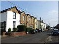
3
Russell Place, Oare
Seen across The Street.
Image: © John Baker
Taken: 6 Jan 2013
0.03 miles
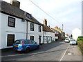
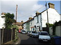
6
![Oare houses [6]](https://s0.geograph.org.uk/geophotos/07/05/66/7056652_3bef407d_120x120.jpg)
Oare houses [6]
This house and shop, numbers 15 and 17 Church Road, was built in the 17th century. Timber framed and later rendered, under a hipped, tile roof. Listed, grade II, with details at: https://historicengland.org.uk/listing/the-list/list-entry/1069090
Oare is a low lying village on the bank of Oare Creek, just over one mile northwest of Faversham. To the north are the Oare Marshes, a nature reserve, an important stopping place for migratory birds. Oare was the southern terminus of the Harty Ferry, which ran across the Swale channel between the Isle of Harty and the mainland. Huguenot refugees founded Oare gunpowder works around 1690 using their knowledge of the advanced French gunpowder.
Image: © Michael Dibb
Taken: 5 Sep 2021
0.04 miles
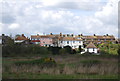

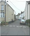
9
![Oare buildings [2]](https://s0.geograph.org.uk/geophotos/07/05/66/7056656_bd67de34_120x120.jpg)
Oare buildings [2]
Now the village hall, this small building in Church Road, started life as an infants school.
Oare is a low lying village on the bank of Oare Creek, just over one mile northwest of Faversham. To the north are the Oare Marshes, a nature reserve, an important stopping place for migratory birds. Oare was the southern terminus of the Harty Ferry, which ran across the Swale channel between the Isle of Harty and the mainland. Huguenot refugees founded Oare gunpowder works around 1690 using their knowledge of the advanced French gunpowder.
Image: © Michael Dibb
Taken: 5 Sep 2021
0.04 miles