IMAGES TAKEN NEAR TO
Millens Row, Ashford Road, FAVERSHAM, ME13 0NW
Introduction
This page details the photographs taken nearby to Millens Row, Ashford Road, ME13 0NW by members of the Geograph project.
The Geograph project started in 2005 with the aim of publishing, organising and preserving representative images for every square kilometre of Great Britain, Ireland and the Isle of Man.

There are currently over 7.5m images from over14,400 individuals and you can help contribute to the project by visiting https://www.geograph.org.uk
Image Map
Images are licensed for reuse under creativecommons.org/licenses/by-sa/2.0
Notes
- Clicking on the map will re-center to the selected point.
- The higher the marker number, the further away the image location is from the centre of the postcode.
Image Listing (12 Images Found)
Images are licensed for reuse under creativecommons.org/licenses/by-sa/2.0
Image
Details
Distance
1
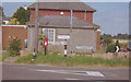
Direction Sign - Signpost by the A251, south of Faversham
Lost finial - 1 arm; Kent RDC halo by the A251, in parish of Badlesmere (Swale District), junction with Bagshill Road, on grass verge. For a more recent photo see https://www.geograph.org.uk/photo/6042464.
Surveyed
Milestone Society National ID: KE_TR0055
Image: © Milestone Society
Taken: 1 Jan 2008
0.02 miles
2
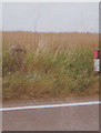
Old Milestone by the A251, Ashford Road, Badlesmere
Stone post (plate lost) by the A251, in parish of Sheldwich (Swale District), Ashford Road, Badlesmere, on the verge beside path by open field, on West side of road. Faversham iron plate, erected by the Faversham to Hythe & Canterbury turnpike trust in the 19th century.
Inscription once read:-
(FAVERSHAM)
(4 MILES)
(ASHFORD)
(9 MILES)
Carved benchmark recorded.
Kent HER.
HER Number: TR 05 NW 164 https://www.heritagegateway.org.uk/Gateway/Results_Single.aspx?uid=MKE34170&resourceID=1005
Milestone Society National ID: KE_FVAF04
Image: © C Woodward
Taken: 30 Jul 2008
0.08 miles
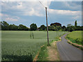
4
Thatched house - Chase Cottage
On the A251 Ashford Road from Dayton Road. An unusually steep roof for a thatched building.
Image: © Penny Mayes
Taken: 1 Apr 2007
0.12 miles
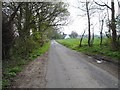
5
Dayton Road
Windy lane towards Badlestone Court, past crop fields.
Image: © Oast House Archive
Taken: 31 May 2011
0.14 miles
6
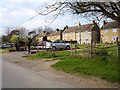
Airey houses on Leaveland Road
Airey houses were post WWII system built concrete houses. The concrete has deteriorated over the years and most (as here) have now been bricked around.
Image: © Penny Mayes
Taken: 9 Apr 2007
0.19 miles
7
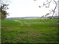
Looking towards Lords Farm
From Bagshill Road.
Image: © Penny Mayes
Taken: 9 Apr 2007
0.19 miles
8

Borage near Leaveland
Growing by Bagshill Road.
Image: © pam fray
Taken: 28 May 2021
0.20 miles
9
A251 Ashford Road
Heading towards Faversham.
Image: © Robin Webster
Taken: 8 Feb 2018
0.21 miles
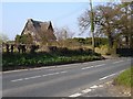
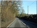
10
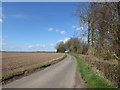
Bagshill Road
This peaceful scene is just off the busy Faversham to Ashford Road (A251). Throwley is the next place in this direction.
Image: © Marathon
Taken: 21 Mar 2017
0.23 miles