IMAGES TAKEN NEAR TO
Throwley, FAVERSHAM, ME13 0JR
Introduction
This page details the photographs taken nearby to ME13 0JR by members of the Geograph project.
The Geograph project started in 2005 with the aim of publishing, organising and preserving representative images for every square kilometre of Great Britain, Ireland and the Isle of Man.

There are currently over 7.5m images from over14,400 individuals and you can help contribute to the project by visiting https://www.geograph.org.uk
Image Map
Images are licensed for reuse under creativecommons.org/licenses/by-sa/2.0
Notes
- Clicking on the map will re-center to the selected point.
- The higher the marker number, the further away the image location is from the centre of the postcode.
Image Listing (3 Images Found)
Images are licensed for reuse under creativecommons.org/licenses/by-sa/2.0
Image
Details
Distance
1
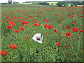
Albino Poppy
In this oil seed rape field, is a mass of common poppies (red poppy). The single white poppy is an Opium Poppy (Papaver somniferum). Seen close to a footpath from Badlesmere to Bethal Row.
Image: © David Anstiss
Taken: 24 Jun 2009
0.06 miles
2
Footpath to Bethel Row
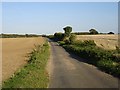
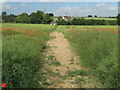
This footpath is from A251 Ashford Road, near Leaveland. It leads to a small row of farm cottages and then on to Throwley Forstal. It is going through an oil seed rape field.
Image: © David Anstiss
Taken: 24 Jun 2009
0.06 miles