IMAGES TAKEN NEAR TO
Hillside Road, FAVERSHAM, ME13 0JF
Introduction
This page details the photographs taken nearby to Hillside Road, ME13 0JF by members of the Geograph project.
The Geograph project started in 2005 with the aim of publishing, organising and preserving representative images for every square kilometre of Great Britain, Ireland and the Isle of Man.

There are currently over 7.5m images from over14,400 individuals and you can help contribute to the project by visiting https://www.geograph.org.uk
Image Map
Images are licensed for reuse under creativecommons.org/licenses/by-sa/2.0
Notes
- Clicking on the map will re-center to the selected point.
- The higher the marker number, the further away the image location is from the centre of the postcode.
Image Listing (16 Images Found)
Images are licensed for reuse under creativecommons.org/licenses/by-sa/2.0
Image
Details
Distance
2
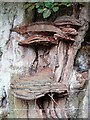
Bracket fungus
Growing on a very old beech tree.
Image: © Penny Mayes
Taken: 1 Aug 2006
0.08 miles
5
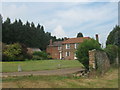
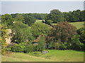
Woodsell Farmhouse
This farm is on an access way from Hillside Road. A bridleway passes the farm heading to Great Spelty Wood.
Image: © David Anstiss
Taken: 28 Jun 2009
0.10 miles
6
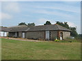
Woodsell Flint Barn
This nice barn is in Woodsell Farm. Close to a bridleway from Hillside Road to Great Spelty Wood.
Image: © David Anstiss
Taken: 28 Jun 2009
0.12 miles
7
Old School House, Stalisfield
This isolated building stands about midway between the village and the church and is now a private house. Stalisfield school closed in 1970 but whether it was still housed in this lovely old building at that time, I don't know. The primary age children from the village moved to Eastling School. The bright reddish gold crop opposite the school (glimpsed between the trees) is flax, grown for linseed oil.
Image: © Penny Mayes
Taken: 1 Aug 2006
0.12 miles
8
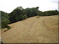
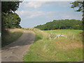
Bridleway from Hillside Road
This track runs through Spuckles Wood along the top of a ridge between valleys. The parched grass shows what a hot, dry summer we have had so far this year.
Image: © Penny Mayes
Taken: 1 Aug 2006
0.13 miles
9
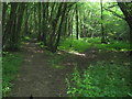
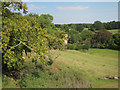
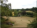
Footpath junction in Spuckles Wood
A bridleway from Thorneycroft Road leads leftwards to Hillside road, opposite Woodsell Farm. A footpath also leads right (less used) to Hillside Road.
Image: © David Anstiss
Taken: 28 Jun 2009
0.13 miles
10
Old School House
A grade II listed http://list.english-heritage.org.uk/resultsingle.aspx?uid=1281774 C16 timber framed house.
Image: © Oast House Archive
Taken: 19 Aug 2011
0.14 miles