IMAGES TAKEN NEAR TO
Housefield Road, FAVERSHAM, ME13 0JB
Introduction
This page details the photographs taken nearby to Housefield Road, ME13 0JB by members of the Geograph project.
The Geograph project started in 2005 with the aim of publishing, organising and preserving representative images for every square kilometre of Great Britain, Ireland and the Isle of Man.

There are currently over 7.5m images from over14,400 individuals and you can help contribute to the project by visiting https://www.geograph.org.uk
Image Map
Images are licensed for reuse under creativecommons.org/licenses/by-sa/2.0
Notes
- Clicking on the map will re-center to the selected point.
- The higher the marker number, the further away the image location is from the centre of the postcode.
Image Listing (6 Images Found)
Images are licensed for reuse under creativecommons.org/licenses/by-sa/2.0
Image
Details
Distance
1
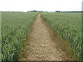
Footpath to Housefield Road
This path leads from Oast Lane, near Cadman's Farm, leading through the field to Housefield Road.
Image: © David Anstiss
Taken: 28 Jun 2009
0.08 miles
2
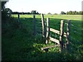
Stile onto footpath
From Housefield Lane. The footpath cuts off the corner the road makes and heads straight to the house at the junction of Oast Lane.
Image: © Penny Mayes
Taken: 20 Sep 2006
0.10 miles
4
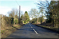
Faversham Road
Heading towards Faversham.
Image: © Robin Webster
Taken: 8 Feb 2018
0.17 miles
5
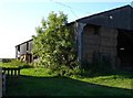
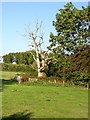
Barn at Cadman's Farm
The bales stored here seem to be an unusual shape.
Image: © Penny Mayes
Taken: 20 Sep 2006
0.18 miles
6
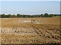
Harrowing at Cadman's Farm
It was easy to see just where the tractor was from the activity of the seagulls.
Image: © Penny Mayes
Taken: 20 Sep 2006
0.22 miles