IMAGES TAKEN NEAR TO
Stalisfield Green, FAVERSHAM, ME13 0HX
Introduction
This page details the photographs taken nearby to Stalisfield Green, ME13 0HX by members of the Geograph project.
The Geograph project started in 2005 with the aim of publishing, organising and preserving representative images for every square kilometre of Great Britain, Ireland and the Isle of Man.

There are currently over 7.5m images from over14,400 individuals and you can help contribute to the project by visiting https://www.geograph.org.uk
Image Map
Images are licensed for reuse under creativecommons.org/licenses/by-sa/2.0
Notes
- Clicking on the map will re-center to the selected point.
- The higher the marker number, the further away the image location is from the centre of the postcode.
Image Listing (10 Images Found)
Images are licensed for reuse under creativecommons.org/licenses/by-sa/2.0
Image
Details
Distance
1
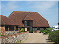
Redborough Barn
Part of a group of buildings on Stalisfield Road. Flint wall on left is part of Redborough Farm house.
Image: © David Anstiss
Taken: 10 May 2009
0.02 miles
2
Poppy Barn
This is a converted horse stable/barn which was a part of Redborough Farm on Stalisfield Road. Another large barn and the farmhouse are all now separate houses.
Image: © David Anstiss
Taken: 10 May 2009
0.02 miles
3

Entrance to Redborough Farm
This is a very remote and little-known part of Kent. This is the entrance to Redborough Farm, seen from Stalisfield Road.
Image: © Marathon
Taken: 13 Oct 2017
0.04 miles
4
The Valley
This may not actually be "the valley" as mentioned on my old 1940s map but the closest farm is Valley Farm and Image are just up the hill to the left (east).
Image: © Penny Mayes
Taken: 1 Aug 2006
0.10 miles
5
Redborough Cottage
On Stalisfield Road, beside Oak Hall House (white fence).
Image: © David Anstiss
Taken: 10 May 2009
0.11 miles
6
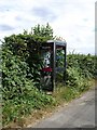
Telephone box near Hillside Road
Many rural phone boxes are still the old red K6 type, having been classified as listed buildings. They certainly stand out better than this modern glass one which is being swallowed by the hedgerow.
Image: © Penny Mayes
Taken: 1 Aug 2006
0.12 miles
7
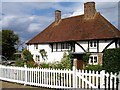
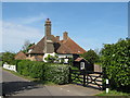
Oak Cottage, Stalisfield
There seems to be some confusion over the name of this house. The large scale map shows it as Oak Cottage but it appears elsewhere as Oak Hall House.
Image: © Penny Mayes
Taken: 1 Aug 2006
0.12 miles
8
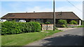
Barns at Green Farm
Brinsley Cottages seen to the left on Hillside Road.
Image: © Oast House Archive
Taken: 19 Aug 2011
0.17 miles
9
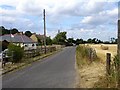
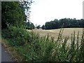
Valley Cottages
Stalisfield Road, north of Stalisfield Green, well outside the main village.
Image: © Penny Mayes
Taken: 1 Aug 2006
0.19 miles
10
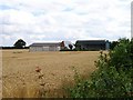
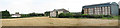
Barns at Green Farm, Stalisfield
A nice selection of styles, the oldest being the central timber-framed one with the huge corrugated iron roof which would originally have been tiled with Kent pegs. The wheat looks ready to cut.
Image: © Penny Mayes
Taken: 1 Aug 2006
0.24 miles