IMAGES TAKEN NEAR TO
Bunce Court Road, FAVERSHAM, ME13 0BU
Introduction
This page details the photographs taken nearby to Bunce Court Road, ME13 0BU by members of the Geograph project.
The Geograph project started in 2005 with the aim of publishing, organising and preserving representative images for every square kilometre of Great Britain, Ireland and the Isle of Man.

There are currently over 7.5m images from over14,400 individuals and you can help contribute to the project by visiting https://www.geograph.org.uk
Image Map
Images are licensed for reuse under creativecommons.org/licenses/by-sa/2.0
Notes
- Clicking on the map will re-center to the selected point.
- The higher the marker number, the further away the image location is from the centre of the postcode.
Image Listing (50 Images Found)
Images are licensed for reuse under creativecommons.org/licenses/by-sa/2.0
Image
Details
Distance
1
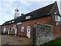
Stable Cottages, Otterden Place
Otterden Place is an early 17th-century estate with a house and parkland. The park was laid out during the mid-18th century.
Image: © pam fray
Taken: 9 Jan 2023
0.01 miles
2
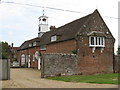
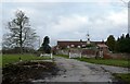
Otterden Place Stables
Part of a group of buildings in the Otterden Estate.
Image: © David Anstiss
Taken: 10 May 2009
0.01 miles
3
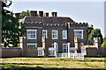
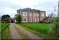
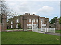
Otterden Place -
With the Norman Conquest, Otterden Manor formed part of the estates of Odo, Bishop of Bayeux, the half brother of William the Conqueror,who fought with William at Hastings. Upon the disgrace of Odo of Bayeux, the property was confiscated by the Crown and there were subsequently a number of different family owners through the centuries.
It was in the grounds of Otterden Place, around 1729, that Dr Stephen Gray and the Reverend Granville Wheeler are said to have carried out very early experiments in electricity.
Today's Otterden Place is a brick 'Tudor' manor house, largely rebuilt in the Eighteenth Century. Very recent wall repairs are evident in this photograph.
Image: © Brian Chadwick
Taken: 26 Jul 2012
0.01 miles
4
St Lawrence, Otterden, Kent - Churchyard
Image: © John Salmon
Taken: 20 May 2009
0.03 miles
5
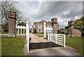
Otterden Place
The track through the gate leads to Hurstwood Road. Otterden Place is an early 17th-century estate with a house and parkland. The park was laid out during the mid-18th century.
Image: © pam fray
Taken: 9 Jan 2023
0.04 miles
6
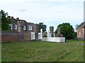
Otterden Place
Otterden Place is an early 17th-century estate with a house and parkland. The park was laid out during the mid-18th century. The mansion, GV II* listed was built by Sir Anthony Aucher in mid 16th century, altered early 18th century and 1787-88. Altered and partly rebuilt by William Pilkington for Granville Hastings Wheler 1801-3.
Image: © pam fray
Taken: 9 Jan 2023
0.04 miles
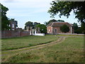
8
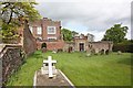
Otterden Place
Otterden Place is from the early 19th century. It stands next to St Lawrence Church which dates from the 1750s and is a typical red-brick box of the time- the church is just on the edge of the photograph to the right. Both are a long way from the village. Sheep graze nearby in this peaceful spot. St Lawrence is now a private chapel, and services are normally only held in this building during summer months.
Image: © Marathon
Taken: 26 Aug 2012
0.04 miles
9
Otterden Place
On access road from Otterden Road. For more details see http://web.onetel.net.uk/~hcwyld/otterden/history.html
Image: © David Anstiss
Taken: 10 May 2009
0.05 miles
10
St Lawrence Church and Otterden Place
St Lawrence Church dates from the 1750s and is a typical red-brick box of the time. It stands in the park next to Otterden Place which is from the early 19th century. Both are a long way from the village. Sheep graze nearby in this peaceful spot. St Lawrence is now a private chapel, and services are normally only held in this building during summer months.
Image: © Marathon
Taken: 26 Aug 2012
0.05 miles