IMAGES TAKEN NEAR TO
Stalisfield, FAVERSHAM, ME13 0BS
Introduction
This page details the photographs taken nearby to ME13 0BS by members of the Geograph project.
The Geograph project started in 2005 with the aim of publishing, organising and preserving representative images for every square kilometre of Great Britain, Ireland and the Isle of Man.

There are currently over 7.5m images from over14,400 individuals and you can help contribute to the project by visiting https://www.geograph.org.uk
Image Map
Images are licensed for reuse under creativecommons.org/licenses/by-sa/2.0
Notes
- Clicking on the map will re-center to the selected point.
- The higher the marker number, the further away the image location is from the centre of the postcode.
Image Listing (10 Images Found)
Images are licensed for reuse under creativecommons.org/licenses/by-sa/2.0
Image
Details
Distance
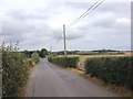
3
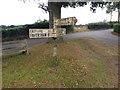
Fingerpost, Otterden Road, Stalisfield
Image: © Chris Whippet
Taken: 20 Sep 2016
0.03 miles
5
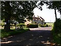
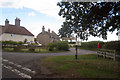
Corner House
I think perhaps the Corner House (as marked on the map) is the one obscured by the tree. The main road here is Otterden Road, the unnamed one to the left goes to Snoad Farm and Frith.
Image: © Penny Mayes
Taken: 8 Jun 2006
0.06 miles
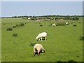
8
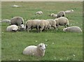
Sheep by Otterden Road, Otterden
On Wingfield Farm.
Image: © pam fray
Taken: 18 Aug 2020
0.14 miles
9
Sheep at Snoad Farm
The unshorn lamb looks nearly as big as the shorn ewe.
Image: © Penny Mayes
Taken: 8 Jun 2006
0.19 miles
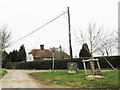
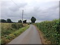
10
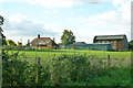
Snoad Farm
This really deserves to be viewed after it has snowed!
Image: © Robin Webster
Taken: 8 Oct 2015
0.24 miles