IMAGES TAKEN NEAR TO
Otterden Road, FAVERSHAM, ME13 0BL
Introduction
This page details the photographs taken nearby to Otterden Road, ME13 0BL by members of the Geograph project.
The Geograph project started in 2005 with the aim of publishing, organising and preserving representative images for every square kilometre of Great Britain, Ireland and the Isle of Man.

There are currently over 7.5m images from over14,400 individuals and you can help contribute to the project by visiting https://www.geograph.org.uk
Image Map
Images are licensed for reuse under creativecommons.org/licenses/by-sa/2.0
Notes
- Clicking on the map will re-center to the selected point.
- The higher the marker number, the further away the image location is from the centre of the postcode.
Image Listing (13 Images Found)
Images are licensed for reuse under creativecommons.org/licenses/by-sa/2.0
Image
Details
Distance
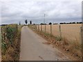
1
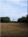
Power lines
Crossing a ploughed field south of Eastling.
Image: © Penny Mayes
Taken: 13 Sep 2006
0.04 miles
2
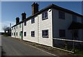
Mill Cottages, Otterden Road near Eastling
Presumably the name of these dwellings refers to Eastling Mill, a smock mill built in 1823 and demolished in c1912.
Image: © pam fray
Taken: 21 Mar 2020
0.05 miles
3
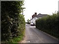
Rural terrace
On Otterden Road south of Eastling, probably built as farm workers' houses.
Image: © Penny Mayes
Taken: 13 Sep 2006
0.10 miles
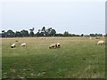
5
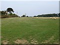
Meadow near Wingfield Farm
The view east from this junction http://www.geograph.org.uk/photo/239749
Image: © Penny Mayes
Taken: 13 Sep 2006
0.17 miles
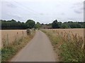
8
Looking back up the hill
Image: © Penny Mayes
Taken: 13 Sep 2006
0.20 miles
9
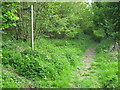
Footpath junction in Divan Wood
A bridleway heads straight on to Gravel Hill, from Kettle Hill Road.
A footpath heads left through Divan Wood to Stalisfield Road.
Image: © David Anstiss
Taken: 10 May 2009
0.21 miles
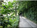
10
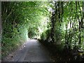
Green tunnel
The road from Wingfield Farm to Kettle Hill dips down and up a narrow valley, common on the dip slope of the North Downs.
Image: © Penny Mayes
Taken: 13 Sep 2006
0.21 miles