IMAGES TAKEN NEAR TO
Eastling, FAVERSHAM, ME13 0BD
Introduction
This page details the photographs taken nearby to ME13 0BD by members of the Geograph project.
The Geograph project started in 2005 with the aim of publishing, organising and preserving representative images for every square kilometre of Great Britain, Ireland and the Isle of Man.

There are currently over 7.5m images from over14,400 individuals and you can help contribute to the project by visiting https://www.geograph.org.uk
Image Map
Images are licensed for reuse under creativecommons.org/licenses/by-sa/2.0
Notes
- Clicking on the map will re-center to the selected point.
- The higher the marker number, the further away the image location is from the centre of the postcode.
Image Listing (16 Images Found)
Images are licensed for reuse under creativecommons.org/licenses/by-sa/2.0
Image
Details
Distance
1
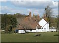
Arnold's Oak Farmhouse, Eastling
Once a manor house. 16th century, extended in the early 19th century. Grade II listed.
Image: © pam fray
Taken: 5 May 2021
0.01 miles
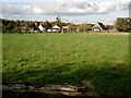
3
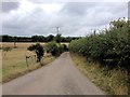
Arnold's Oak Farm
An eclectic mix of buildings behind the farmhouse.
Image: © Penny Mayes
Taken: 13 Sep 2006
0.04 miles
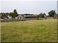
4
Arnold's Oak Farm
A closer view of the farmhouse and outbuildings with posing sheep.
Image: © Penny Mayes
Taken: 13 Sep 2006
0.04 miles
5
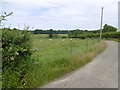
Lane near Arnold's Oak Farm
The unnamed lane ahead leads from Kettle Hill Road to Stalisfield Road, passing between Barn Wood and Great Bradfield Wood. This is the view from the junction with Kettle Hill Road. Broomham Wood lies ahead.
Image: © Marathon
Taken: 7 Jul 2016
0.05 miles
6
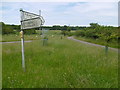
Junction of lanes near Arnold's Oak Farm
The unnamed lane ahead leads from Kettle Hill Road to Stalisfield Road, passing between Barn Wood and Great Bradfield Wood. This is the view from Kettle Hill Road.
Image: © Marathon
Taken: 7 Jul 2016
0.05 miles
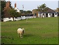
7
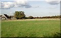
Arnold's Oak Farm
Sheep grazing in the distance and the trees beginning to show autumn colours.
Image: © Bikeboy
Taken: 30 Oct 2012
0.06 miles
9
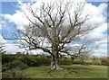
Arnold's Oak, Eastling
On Arnold's Oak Farm. There was a man trap on the ground many years ago and the tree grew through it, lifting higher and higher as it grew. It must be many feet up by now but too difficult to see. At the base of the tree on the left is a plaque to that effect.
Image: © pam fray
Taken: 5 May 2021
0.06 miles
10
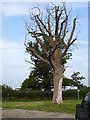
Arnold's Oak
...is thriving, in the field beyond the dead one on the road junction. The tree beyond the hedge looks about the same age as the dead one. I've no idea who Arnold was, but a resident of the farm tells me the house is on a site mentioned in the Doomsday Book as the 'holding of Arnoldton' so I guess he was around in 1085.
I have received an email from Sydney Lippingwell who says, "I thought you may be interested to know that there used to be a man-trap in this tree. It had been there so long that the tree had grown round it.
My mother's family used to live 100 yards away at Kettle Hill."
Update September 2014: an email from Robin Mackay Miller states, "I visited the surviving oak on the weekend, after asking my godfather if the man trap was still there. The man trap is actually still embedded in the live tree in the field behind, although now some 6-8 ft above ground level. It's worth a visit, though there's no sign of the dead tree."
Update December 2022: from street view 2009, a new tree had been planted on the junction and was looking quite good on the September 2022 visit of the Google car https://goo.gl/maps/bbjSxMNPZmKczEpc6.
Image: © Penny Mayes
Taken: 13 Sep 2006
0.07 miles