IMAGES TAKEN NEAR TO
Stalisfield Road, FAVERSHAM, ME13 0AB
Introduction
This page details the photographs taken nearby to Stalisfield Road, ME13 0AB by members of the Geograph project.
The Geograph project started in 2005 with the aim of publishing, organising and preserving representative images for every square kilometre of Great Britain, Ireland and the Isle of Man.

There are currently over 7.5m images from over14,400 individuals and you can help contribute to the project by visiting https://www.geograph.org.uk
Image Map
Images are licensed for reuse under creativecommons.org/licenses/by-sa/2.0
Notes
- Clicking on the map will re-center to the selected point.
- The higher the marker number, the further away the image location is from the centre of the postcode.
Image Listing (2 Images Found)
Images are licensed for reuse under creativecommons.org/licenses/by-sa/2.0
Image
Details
Distance
1
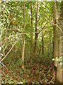
Deadman's Wood
Deadman's Wood lies along the SE side of Stalisfield Road.
Image: © Penny Mayes
Taken: 21 Oct 2006
0.13 miles
2
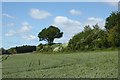
Farmland by Box Lane, near Painters Forstal
The very narrow country lane runs between Stalisfield Road and Eastling Road.
Image: © pam fray
Taken: 6 Jun 2020
0.25 miles