IMAGES TAKEN NEAR TO
Binnacle Road, ROCHESTER, ME1 2XP
Introduction
This page details the photographs taken nearby to Binnacle Road, ME1 2XP by members of the Geograph project.
The Geograph project started in 2005 with the aim of publishing, organising and preserving representative images for every square kilometre of Great Britain, Ireland and the Isle of Man.

There are currently over 7.5m images from over14,400 individuals and you can help contribute to the project by visiting https://www.geograph.org.uk
Image Map
Images are licensed for reuse under creativecommons.org/licenses/by-sa/2.0
Notes
- Clicking on the map will re-center to the selected point.
- The higher the marker number, the further away the image location is from the centre of the postcode.
Image Listing (24 Images Found)
Images are licensed for reuse under creativecommons.org/licenses/by-sa/2.0
Image
Details
Distance
1
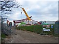
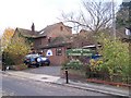
Construction at The Thomas Aveling School
New building on Binnacle Road, beside the school.
Interesting roof shape.
Image: © David Anstiss
Taken: 12 Nov 2008
0.09 miles
4

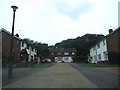
Entrance to The Thomas Aveling School
To the south of Rochester there are a number of fairly steep-sided valleys running north-south. This looks across Arethusa Road to The Thomas Aveling School.
Image: © Marathon
Taken: 27 Oct 2016
0.16 miles
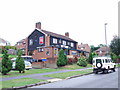
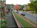
5
Warren House Veterinary Surgery, Rochester
On Anchor Road beside St. Justus Church
Image: © David Anstiss
Taken: 12 Nov 2008
0.16 miles
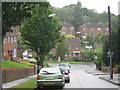
6
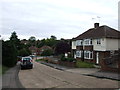
Arethusa Road, Rochester
To the south of Rochester there are a number of fairly steep-sided valleys running north-south. This looks down Arethusa Road to The Tideway with Maidstone Road at the top of the hill on the far side.
Image: © Marathon
Taken: 27 Oct 2016
0.17 miles
8
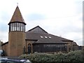
St Justus Church, Rochester
On junction of Anchor Road and Fairway Road.
Tower looks like a lighthouse, especially as church is on a high point.
Image: © David Anstiss
Taken: 12 Nov 2008
0.17 miles