IMAGES TAKEN NEAR TO
Seaview Avenue, SHEERNESS, ME12 4RA
Introduction
This page details the photographs taken nearby to Seaview Avenue, ME12 4RA by members of the Geograph project.
The Geograph project started in 2005 with the aim of publishing, organising and preserving representative images for every square kilometre of Great Britain, Ireland and the Isle of Man.

There are currently over 7.5m images from over14,400 individuals and you can help contribute to the project by visiting https://www.geograph.org.uk
Image Map
Images are licensed for reuse under creativecommons.org/licenses/by-sa/2.0
Notes
- Clicking on the map will re-center to the selected point.
- The higher the marker number, the further away the image location is from the centre of the postcode.
Image Listing (30 Images Found)
Images are licensed for reuse under creativecommons.org/licenses/by-sa/2.0
Image
Details
Distance
6
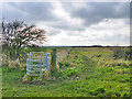
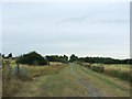
Footpaths, Leysdown
The public footpath goes through the gate and then across an arable field. It seems hardly used, and is probably best left for a drier time of year. On the right of the fence is a well used but unsigned route around the margin of a field of rough grass. This is probably part of 'Leysdown Country and Coastal Park'.
Image: © Robin Webster
Taken: 6 Mar 2016
0.15 miles
7
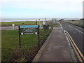
Shellness Road approaching Leysdown Coastal Park
The car park on the left is gated and shut off season.
Image: © Danny P Robinson
Taken: 17 Jan 2009
0.16 miles
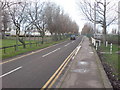
10
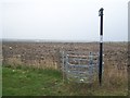
Kissing Gate on Wing Lane
Footpath leads across field then over drainage ditches in Leysdown Marshes to Capel Fleet (large wide dyke).
Image: © David Anstiss
Taken: 1 Mar 2009
0.17 miles