IMAGES TAKEN NEAR TO
Warden Bay Road, SHEERNESS, ME12 4NA
Introduction
This page details the photographs taken nearby to Warden Bay Road, ME12 4NA by members of the Geograph project.
The Geograph project started in 2005 with the aim of publishing, organising and preserving representative images for every square kilometre of Great Britain, Ireland and the Isle of Man.

There are currently over 7.5m images from over14,400 individuals and you can help contribute to the project by visiting https://www.geograph.org.uk
Image Map
Images are licensed for reuse under creativecommons.org/licenses/by-sa/2.0
Notes
- Clicking on the map will re-center to the selected point.
- The higher the marker number, the further away the image location is from the centre of the postcode.
Image Listing (18 Images Found)
Images are licensed for reuse under creativecommons.org/licenses/by-sa/2.0
Image
Details
Distance
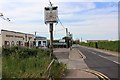
1

Sheppey Evangelical Chapel and convenience store
Image: © Oast House Archive
Taken: 2 Jun 2020
0.00 miles

4

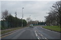
Sheppey Evangelical Church
On Warden Bay Road. Behind is Happy Valley Social Club. Opposite church and newsagent (unseen, to right of the church) is Warden Holiday Village.
Image: © David Anstiss
Taken: 1 Mar 2009
0.02 miles
5
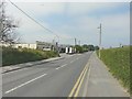
Warden Bay Road, Leysdown-on-Sea
On the left is Sheppey Evangelical Church and beyond that a cafe, where a van is parked opposite
Image: © John Baker
Taken: 26 Jul 2012
0.02 miles
6
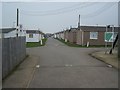
Isle of Sheppey Holiday Village
On Warden Bay Road, access road leads into rows and rows of caravans.
Image: © David Anstiss
Taken: 1 Mar 2009
0.04 miles
7
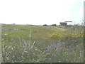
Former trackbed of Sheppey Light Railway
Looking in a westerly direction from Warden Bay Road. According to http://www.sheppeywebsite.co.uk/index.php?id=95 The Sheppey Light Railway opened on 1 August 1901 and closed on 4 December 1950. The total length was 8 miles 52 chains. It ran from Queenborough (where there was a north-facing bay platform on the east side of the station) to Leysdown with intermediate stations at Sheerness East, East Minster-on-Sea (which was actually west of Minster), Minster-on-Sea (they're only given as Minster in the link), Brambledown Halt, Eastchurch and Harty Road Halt. Today, one can trace most of the route from the air and on the Ordnance Survey map (Explorer 149). On the ground, one can find sections overgrown with grass, brambles and trees (as here), sections built over, sections concreted over to form a permanent way or landscaped to form paths for pedestrians.
Image: © John Baker
Taken: 26 Jul 2012
0.04 miles
8

Leysdown-On-Sea, Isle of Sheppey, Kent
Image: © Oast House Archive
Taken: 17 Aug 2008
0.11 miles
9
Leysdown Road meets Warden Bay Road
This view of Leysdown Road near the turn off for Warden looks in the direction of Leysdown-on-Sea.
Image: © Marathon
Taken: 4 Feb 2017
0.11 miles