IMAGES TAKEN NEAR TO
Church Road, SHEERNESS, ME12 4DH
Introduction
This page details the photographs taken nearby to Church Road, ME12 4DH by members of the Geograph project.
The Geograph project started in 2005 with the aim of publishing, organising and preserving representative images for every square kilometre of Great Britain, Ireland and the Isle of Man.

There are currently over 7.5m images from over14,400 individuals and you can help contribute to the project by visiting https://www.geograph.org.uk
Image Map
Images are licensed for reuse under creativecommons.org/licenses/by-sa/2.0
Notes
- Clicking on the map will re-center to the selected point.
- The higher the marker number, the further away the image location is from the centre of the postcode.
Image Listing (15 Images Found)
Images are licensed for reuse under creativecommons.org/licenses/by-sa/2.0
Image
Details
Distance
1
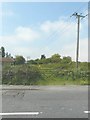
Former trackbed of Sheppey Light Railway
Looking in an easterly direction across Church Road. According to http://www.sheppeywebsite.co.uk/index.php?id=95 The Sheppey Light Railway opened on 1 August 1901 and closed on 4 December 1950. The total length was 8 miles 52 chains. It ran from Queenborough (where there was a north-facing bay platform on the east side of the station) to Leysdown with intermediate stations at Sheerness East, East Minster-on-Sea (which was actually west of Minster), Minster-on-Sea (they're only given as Minster in the link), Brambledown Halt, Eastchurch and Harty Road Halt. Today, one can trace most of the route from the air and on the Ordnance Survey map (Explorer 149). On the ground, one can find sections overgrown with grass, brambles and trees (as here), sections built over, sections concreted over to form a permanent way or landscaped to form paths for pedestrians.
Image: © John Baker
Taken: 26 Jul 2012
0.02 miles


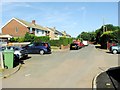
4
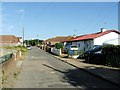
Church Road
The junction of Longmore Drive is seen on the left, while the bus is waiting for passengers to board opposite a house that is being built on the corner of Orchard Way.
Image: © John Baker
Taken: 26 Jul 2012
0.04 miles
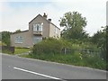
5
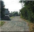
Site of former Eastchurch station, 1995
View northward, across the location of a crossing on the ex-SE&CR Sheppey Light Railway, Queenborough (to left) - Leysdown (to right), which closed long ago, on 4/12/50. (Cf. Image]).
Image: © Ben Brooksbank
Taken: 11 Mar 1995
0.05 miles
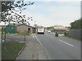
6
Former trackbed of Sheppey Light Railway
Seen across Church Road. According to http://www.sheppeywebsite.co.uk/index.php?id=95 The Sheppey Light Railway opened on 1 August 1901 and closed on 4 December 1950. The total length was 8 miles 52 chains. It ran from Queenborough (where there was a north-facing bay platform on the east side of the station) to Leysdown with intermediate stations at Sheerness East, East Minster-on-Sea (which was actually west of Minster), Minster-on-Sea (they're only given as Minster in the link), Brambledown Halt, Eastchurch (which was located here) and Harty Road Halt. Today, one can trace most of the route from the air and on the Ordnance Survey map (Explorer 149). On the ground, one can find sections overgrown with grass, brambles and trees (as here), sections built over, sections concreted over to form a permanent way or landscaped to form paths for pedestrians.
Image: © John Baker
Taken: 26 Jul 2012
0.05 miles
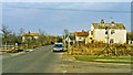
9
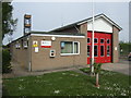
Eastchurch Fire Station
Adjacent to the HMP Swaleside complex.
Image: © Jonathan Billinger
Taken: 25 Apr 2007
0.07 miles