IMAGES TAKEN NEAR TO
Hunsdon Close, SHEERNESS, ME12 4AU
Introduction
This page details the photographs taken nearby to Hunsdon Close, ME12 4AU by members of the Geograph project.
The Geograph project started in 2005 with the aim of publishing, organising and preserving representative images for every square kilometre of Great Britain, Ireland and the Isle of Man.

There are currently over 7.5m images from over14,400 individuals and you can help contribute to the project by visiting https://www.geograph.org.uk
Image Map
Images are licensed for reuse under creativecommons.org/licenses/by-sa/2.0
Notes
- Clicking on the map will re-center to the selected point.
- The higher the marker number, the further away the image location is from the centre of the postcode.
Image Listing (5 Images Found)
Images are licensed for reuse under creativecommons.org/licenses/by-sa/2.0
Image
Details
Distance
1
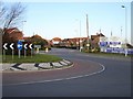
Kingsborough Manor
One of several new housing developments on the Isle of Sheppey.
Image: © Penny Mayes
Taken: 8 Mar 2007
0.15 miles
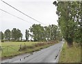
2
Marrowbone Hill, Plough Road
Just to the west of Cripps Farm. It all looks delightfully tranquil but the beyond the left hand side of the road, the fields have been ravaged by Kingsborough Manor - a large estate of new houses.
Image: © John Baker
Taken: 7 Oct 2012
0.15 miles
3
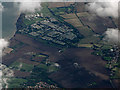
Eastchurch holiday camps from the air
A cluster of holiday parks to the north of Eastchurch, which can be seen on the right.
Image: © Thomas Nugent
Taken: 14 Sep 2015
0.20 miles
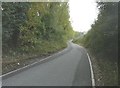
4
Plough Road
A minor road running east-west along a ridge on the north side of the island - and here running parallel to the coast. In the picture, the poplars to the left mark the access track to a holiday site - one of a number off Plough Road.
Image: © Stefan Czapski
Taken: 29 Jul 2017
0.24 miles
5
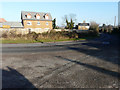
Looking east along Eastchurch Road (B2008)
My previous view of Image showed this house under construction; now it has been completed. It is situated on the Kingsborough Manor housing estate.
Image: © John Baker
Taken: 17 Jan 2017
0.24 miles