IMAGES TAKEN NEAR TO
Danes Drive, SHEERNESS, ME12 4AJ
Introduction
This page details the photographs taken nearby to Danes Drive, ME12 4AJ by members of the Geograph project.
The Geograph project started in 2005 with the aim of publishing, organising and preserving representative images for every square kilometre of Great Britain, Ireland and the Isle of Man.

There are currently over 7.5m images from over14,400 individuals and you can help contribute to the project by visiting https://www.geograph.org.uk
Image Map
Images are licensed for reuse under creativecommons.org/licenses/by-sa/2.0
Notes
- Clicking on the map will re-center to the selected point.
- The higher the marker number, the further away the image location is from the centre of the postcode.
Image Listing (27 Images Found)
Images are licensed for reuse under creativecommons.org/licenses/by-sa/2.0
Image
Details
Distance
3
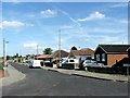
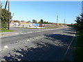
Building site, 349-355, Leysdown Road
Planning permission has been granted by Swale Borough Council under application number SW/14/503846/FULL for the “provision of four 3-bedroom houses, seven 2-bedroom houses, two 2-bedroom bungalows and one 2-bedroom disabled persons bungalow with associated parking court, parking spaces and access driveways”.
The site is visible when Image
Image: © John Baker
Taken: 27 Sep 2015
0.10 miles
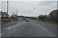
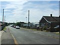
4
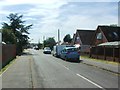
Looking east-northeast along Leysdown Road
To where there is a Image, on the corner of Danes Drive. Planning permission has been granted by Swale Borough Council under application number SW/14/503846/FULL for the “provision of four 3-bedroom houses, seven 2-bedroom houses, two 2-bedroom bungalows and one 2-bedroom disabled persons bungalow with associated parking court, parking spaces and access driveways”.
Image: © John Baker
Taken: 27 Sep 2015
0.10 miles
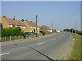
5
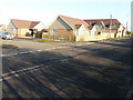
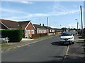
Recently completed houses, Leysdown Road
On my previous visit when I was Image, all I could see was a building site on the corner of Danes Drive.
Image: © John Baker
Taken: 17 Jan 2017
0.10 miles
7
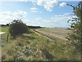
Looking west-southwest from Mustards Road
The area between the hedge and the drainage ditch was, until 62 years ago, the route of The Sheppey Light Railway which according to http://www.sheppeywebsite.co.uk/index.php?id=95 opened on 1 August 1901 and closed on 4 December 1950. The total length was 8 miles 52 chains. It ran from Queenborough (where there was a north-facing bay platform on the east side of the station) to Leysdown with intermediate stations at Sheerness East, East Minster-on-Sea (which was actually west of Minster), Minster-on-Sea (they're only given as Minster in the link), Brambledown Halt, Eastchurch and Harty Road Halt. Today, one can trace most of the route from the air and on the Ordnance Survey map (Explorer 149). On the ground, one can find sections overgrown with grass, brambles and trees, sections built over, sections concreted over to form a permanent way or landscaped to form paths for pedestrians.
Image: © John Baker
Taken: 29 Sep 2012
0.11 miles
9
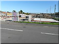
Bay View near Leysdown-on-Sea
A small settlement on the Leysdown Road, a few houses, a pub and a caravan park. It was too hazy to see if there is actually a view of a bay from here.
Image: © Penny Mayes
Taken: 17 Aug 2005
0.12 miles