IMAGES TAKEN NEAR TO
Lower Road, SHEERNESS, ME12 3SY
Introduction
This page details the photographs taken nearby to Lower Road, ME12 3SY by members of the Geograph project.
The Geograph project started in 2005 with the aim of publishing, organising and preserving representative images for every square kilometre of Great Britain, Ireland and the Isle of Man.

There are currently over 7.5m images from over14,400 individuals and you can help contribute to the project by visiting https://www.geograph.org.uk
Image Map
Images are licensed for reuse under creativecommons.org/licenses/by-sa/2.0
Notes
- Clicking on the map will re-center to the selected point.
- The higher the marker number, the further away the image location is from the centre of the postcode.
Image Listing (12 Images Found)
Images are licensed for reuse under creativecommons.org/licenses/by-sa/2.0
Image
Details
Distance
1
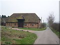
Evergreen Barn
On access road to Groves Farm
Image: © David Anstiss
Taken: 1 Mar 2009
0.02 miles
2
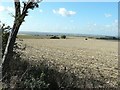
Southwest view from track near Newbuildings Cottages
Image: © John Baker
Taken: 29 Sep 2012
0.07 miles
3
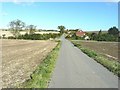
Track between Lower Road and Groves Farm
The house ahead, on the right, is semi-detached with the nearer half called Grove Cottage and the further called Bramblefields
Image: © John Baker
Taken: 29 Sep 2012
0.12 miles
4
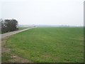
Lane and field in Groves Farm
Lane leads to fields to East of farm.
Buildings in background are part of HM Prison Eastchurch.
Image: © David Anstiss
Taken: 1 Mar 2009
0.16 miles
5
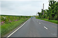
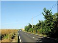
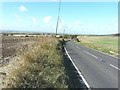
A2500 Lower Road
Heading towards Eastchurch and Leysdown.
Image: © Robin Webster
Taken: 16 May 2018
0.17 miles
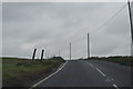
9
Looking southwesterly along Lower Road
There is a sign for Groves Farm at the next turning to the left.
Image: © John Baker
Taken: 29 Sep 2012
0.20 miles
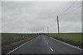
10
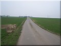
Lane to Groves Farm
On access road past Newbuildings Cottages.
Image: © David Anstiss
Taken: 1 Mar 2009
0.21 miles