IMAGES TAKEN NEAR TO
Chequers Road, SHEERNESS, ME12 3SJ
Introduction
This page details the photographs taken nearby to Chequers Road, ME12 3SJ by members of the Geograph project.
The Geograph project started in 2005 with the aim of publishing, organising and preserving representative images for every square kilometre of Great Britain, Ireland and the Isle of Man.

There are currently over 7.5m images from over14,400 individuals and you can help contribute to the project by visiting https://www.geograph.org.uk
Image Map (21 Images)


Getting Data...Please wait
Leaflet Map data © OpenStreetMap
Images are licensed for reuse under creativecommons.org/licenses/by-sa/2.0
Notes
- Clicking on the map will re-center to the selected point.
- The higher the marker number, the further away the image location is from the centre of the postcode.
Image Listing (21 Images Found)
Images are licensed for reuse under creativecommons.org/licenses/by-sa/2.0
Image
Details
Distance
1
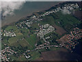
Golden Leas holiday Park from the air
Between Minster and Eastchurch.
Image: © Thomas Nugent
Taken: 14 Sep 2015
0.09 miles
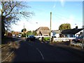
3
Pigtail Corner
Pigtail Corner is on the B2008 Eastchurch Road
Image: © Glyn Baker
Taken: 5 Apr 2007
0.10 miles
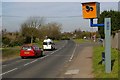
6
Looking towards Tadwell Farm
From Elm Lane.
Image: © John Baker
Taken: 26 Jul 2012
0.17 miles
9
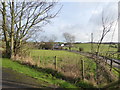
Tadwell Farm
This is the view from Elm Lane at Mill Hill to the east of Minster-in-Sheppey.
Image: © Marathon
Taken: 4 Feb 2017
0.20 miles
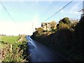
10
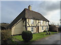
Little Woottons, Minster-in-Sheppey
This attractive house is to be seen in Elm Lane.
Image: © Marathon
Taken: 4 Feb 2017
0.20 miles