IMAGES TAKEN NEAR TO
Halfway Road, SHEERNESS, ME12 3AR
Introduction
This page details the photographs taken nearby to Halfway Road, ME12 3AR by members of the Geograph project.
The Geograph project started in 2005 with the aim of publishing, organising and preserving representative images for every square kilometre of Great Britain, Ireland and the Isle of Man.

There are currently over 7.5m images from over14,400 individuals and you can help contribute to the project by visiting https://www.geograph.org.uk
Image Map
Images are licensed for reuse under creativecommons.org/licenses/by-sa/2.0
Notes
- Clicking on the map will re-center to the selected point.
- The higher the marker number, the further away the image location is from the centre of the postcode.
Image Listing (29 Images Found)
Images are licensed for reuse under creativecommons.org/licenses/by-sa/2.0
Image
Details
Distance
2
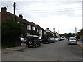
Stable block of The Old Dairy, Halfway Road (A250)
This building was to have been demolished but a resident living opposite objected to the planning application SW/12/0346 that Swale Borough Council raised in April 2012, which stated, “demolition of existing building and re-development of site to provide for six detached chalet bungalows and eight town houses with associated amenity space, parking, landscaping and access”. This application was withdrawn on 6 September 2012. There is a “for sale” board, which was attached to the building by hb, surveyors and valuers, 5th floor, Portland House, 4 Great Portland Street, London WIW 8QJ (I discovered their details through the telephone number on the “for sale” board, although the building didn’t appear on their website)
Image: © John Baker
Taken: 7 Oct 2012
0.04 miles
3
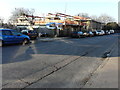
Building site, Halfway Road
Planning permission was granted by Swale Borough Council under application number 14/502847/FULL for the “proposed re-development to provide 6 detached chalet bungalows and 8 town houses complete with associated garages, parking and infrastructure”. The development includes the site of the Image, which has been demolished.
Image: © John Baker
Taken: 17 Jan 2017
0.04 miles
8
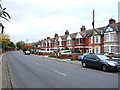
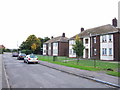
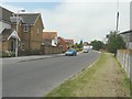
Halfway Road
The house on the right with the silver car parked in front of it is number 87. Between it and the other house (just to the left of the trees) was where The Sheppey Light Railway once ran before crossing the road. According to http://www.sheppeywebsite.co.uk/index.php?id=95 the railway opened on 1 August 1901 and closed on 4 December 1950. The total length was 8 miles 52 chains. It ran from Queenborough (where there was a north-facing bay platform on the east side of the station) to Leysdown with intermediate stations at Sheerness East, East Minster-on-Sea (which was actually west of Minster), Minster-on-Sea (they're only given as Minster in the link), Brambledown Halt, Eastchurch and Harty Road Halt. Today, one can trace most of the route from the air and on the Ordnance Survey map (Explorer 149). On the ground, one can find sections overgrown with grass, brambles and trees, sections built over, sections concreted over to form a permanent way or landscaped to form paths for pedestrians.
Image: © John Baker
Taken: 26 Jul 2012
0.10 miles
9
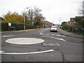
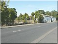
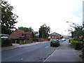
Sheppey Light Railway: Site of the former Sheerness East station
The Sheppey Light Railway ran from Queenborough to Leysdown-on-Sea. It was built to the designs of the renowned light railway engineer, Colonel Fred Holman Stephens, and was opened in 1901. Traffic was never busy on the line and it was taken over by the South Eastern and Chatham Railway in 1905, finally closing in 1950.
The railway crossed over Halfway Road here by means of a level crossing, and the first station along the line from Queenborough was on the other side of the present day roundabout, about where the No Through Road sign is now. Incidentally the road ahead that followed the old track is the endearingly named Power Station Road.
Image: © Nigel Cox
Taken: 24 Nov 2013
0.10 miles
10
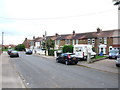
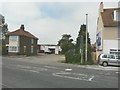
Power Station Road
The houses were built on the former trackbed of The Sheppey Light Railway which according to http://www.sheppeywebsite.co.uk/index.php?id=95 opened on 1 August 1901 and closed on 4 December 1950. The total length was 8 miles 52 chains. It ran from Queenborough (where there was a north-facing bay platform on the east side of the station) to Leysdown with intermediate stations at Sheerness East (which was situated at the far end of this road), East Minster-on-Sea (which was actually west of Minster), Minster-on-Sea (they're only given as Minster in the link), Brambledown Halt, Eastchurch and Harty Road Halt. Today, one can trace most of the route from the air and on the Ordnance Survey map (Explorer 149). On the ground, one can find sections overgrown with grass, brambles and trees, sections built over (as here), sections concreted over to form a permanent way or landscaped to form paths for pedestrians.
Image: © John Baker
Taken: 26 Jul 2012
0.10 miles