IMAGES TAKEN NEAR TO
Winstanley Road, SHEERNESS, ME12 2PW
Introduction
This page details the photographs taken nearby to Winstanley Road, ME12 2PW by members of the Geograph project.
The Geograph project started in 2005 with the aim of publishing, organising and preserving representative images for every square kilometre of Great Britain, Ireland and the Isle of Man.

There are currently over 7.5m images from over14,400 individuals and you can help contribute to the project by visiting https://www.geograph.org.uk
Image Map (Loading...)


Getting Data...Please wait
Leaflet Map data © OpenStreetMap
Images are licensed for reuse under creativecommons.org/licenses/by-sa/2.0
Notes
- Clicking on the map will re-center to the selected point.
- The higher the marker number, the further away the image location is from the centre of the postcode.
Image Listing (76 Images Found)
Images are licensed for reuse under creativecommons.org/licenses/by-sa/2.0
Image
Details
Distance


8
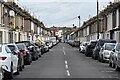
Berridge Road, Sheerness
One of several streets of terraced houses leading back from the seafront: the buildings in the far distance are on Marine Parade.
Image: © David Martin
Taken: 16 Mar 2023
0.10 miles

10
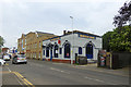
The Queens Head, Sheerness
On the High Street.
Image: © Robin Webster
Taken: 16 May 2018
0.10 miles