IMAGES TAKEN NEAR TO
Winstanley Road, SHEERNESS, ME12 2PL
Introduction
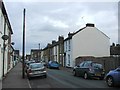
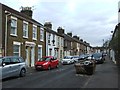
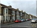
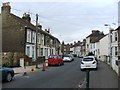
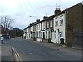
This page details the photographs taken nearby to Winstanley Road, ME12 2PL by members of the Geograph project.
The Geograph project started in 2005 with the aim of publishing, organising and preserving representative images for every square kilometre of Great Britain, Ireland and the Isle of Man.

There are currently over 7.5m images from over14,400 individuals and you can help contribute to the project by visiting https://www.geograph.org.uk
Image Map
Images are licensed for reuse under creativecommons.org/licenses/by-sa/2.0
Notes
- Clicking on the map will re-center to the selected point.
- The higher the marker number, the further away the image location is from the centre of the postcode.
Image Listing (178 Images Found)
Images are licensed for reuse under creativecommons.org/licenses/by-sa/2.0
Image
Details
Distance


9

Vintage 1977 Ford Capri, Alma Road, Sheerness
Image: © Chris Whippet
Taken: 1 Apr 2015
0.06 miles
10
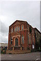
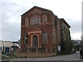
Former water tower and pumping station, Trinity Road, Sheerness
The rearmost of the two buildings was erected in 1840s with this front building added in 1891. The building contains three wells, one with an 18 inch borehole reaching down 805 ft from the surface. The tower provided the Isle of Sheppey with water until 1960. Previously Grade II Listed it was removed from protection in 1988 despite being regarded as historically important. Over the years many proposals have been made for use of the site until in 2000 the buildings came under the Mile Town conservation area. A housing application in 2002 was withdrawn but one in 2005 was granted but appears to have come to nothing. An application to demolish it in 2012 was rejected.
Image: © Jo and Steve Turner
Taken: 29 Jun 2016
0.06 miles