IMAGES TAKEN NEAR TO
Alma Road, SHEERNESS, ME12 2NZ
Introduction
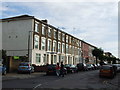
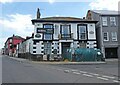
This page details the photographs taken nearby to Alma Road, ME12 2NZ by members of the Geograph project.
The Geograph project started in 2005 with the aim of publishing, organising and preserving representative images for every square kilometre of Great Britain, Ireland and the Isle of Man.

There are currently over 7.5m images from over14,400 individuals and you can help contribute to the project by visiting https://www.geograph.org.uk
Image Map
Images are licensed for reuse under creativecommons.org/licenses/by-sa/2.0
Notes
- Clicking on the map will re-center to the selected point.
- The higher the marker number, the further away the image location is from the centre of the postcode.
Image Listing (115 Images Found)
Images are licensed for reuse under creativecommons.org/licenses/by-sa/2.0
Image
Details
Distance
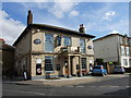
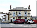
3
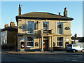
The Napier, Sheerness
A free house named after Admiral Sir Charles John Napier, 1786 - 1860.
Image: © Robin Webster
Taken: 16 Feb 2014
0.02 miles
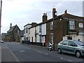

10
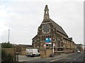
Sheerness: Roman Catholic Church of St Henry & St Elizabeth
The church was built to the designs of Edward Welby Pugin in 1863/4. It is a Grade II Listed Building.
Image: © Nigel Cox
Taken: 24 Nov 2013
0.05 miles