IMAGES TAKEN NEAR TO
Ranelagh Road, SHEERNESS, ME12 2NS
Introduction
This page details the photographs taken nearby to Ranelagh Road, ME12 2NS by members of the Geograph project.
The Geograph project started in 2005 with the aim of publishing, organising and preserving representative images for every square kilometre of Great Britain, Ireland and the Isle of Man.

There are currently over 7.5m images from over14,400 individuals and you can help contribute to the project by visiting https://www.geograph.org.uk
Image Map
Images are licensed for reuse under creativecommons.org/licenses/by-sa/2.0
Notes
- Clicking on the map will re-center to the selected point.
- The higher the marker number, the further away the image location is from the centre of the postcode.
Image Listing (173 Images Found)
Images are licensed for reuse under creativecommons.org/licenses/by-sa/2.0
Image
Details
Distance

3
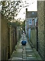
The mystery of the blue ball
An alley from Fonblanque Road to Meyrick Road and onwards.
Image: © Robin Webster
Taken: 16 Feb 2014
0.05 miles


9

Vintage 1977 Ford Capri, Alma Road, Sheerness
Image: © Chris Whippet
Taken: 1 Apr 2015
0.06 miles
10
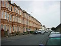
Terraced houses on Marine Parade, Sheerness
I'm told this is known as Shrimp Terrace.
No view of the sea from the ground floor but it lies just behind the sea wall on the right of the picture. Looking west towards the town.
Image: © Penny Mayes
Taken: 2 Aug 2005
0.06 miles