IMAGES TAKEN NEAR TO
Nunnery Grove, SHEERNESS, ME12 2GD
Introduction
This page details the photographs taken nearby to Nunnery Grove, ME12 2GD by members of the Geograph project.
The Geograph project started in 2005 with the aim of publishing, organising and preserving representative images for every square kilometre of Great Britain, Ireland and the Isle of Man.

There are currently over 7.5m images from over14,400 individuals and you can help contribute to the project by visiting https://www.geograph.org.uk
Image Map
Images are licensed for reuse under creativecommons.org/licenses/by-sa/2.0
Notes
- Clicking on the map will re-center to the selected point.
- The higher the marker number, the further away the image location is from the centre of the postcode.
Image Listing (140 Images Found)
Images are licensed for reuse under creativecommons.org/licenses/by-sa/2.0
Image
Details
Distance
1
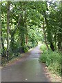
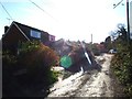
Love Lane, Minster-in-Sheppey
Leading downhill past a small suburban park.
Image: © Stefan Czapski
Taken: 29 Jul 2017
0.02 miles
6
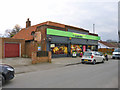
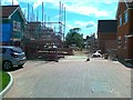
Co-operative food shop, Queens Road, Minster
The painted sign on the side suggests this was once a hardware store, but nothing else can be made out. A similar sign on the other side is even less legible.
Image: © Robin Webster
Taken: 6 Mar 2016
0.11 miles
9
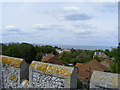
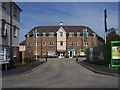
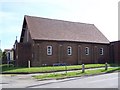
View toward Thames Estuary from roof of Minster Abbey Gatehouse
Image: © PAUL FARMER
Taken: 3 May 2009
0.11 miles