IMAGES TAKEN NEAR TO
Kent Avenue, SHEERNESS, ME12 2DZ
Introduction
This page details the photographs taken nearby to Kent Avenue, ME12 2DZ by members of the Geograph project.
The Geograph project started in 2005 with the aim of publishing, organising and preserving representative images for every square kilometre of Great Britain, Ireland and the Isle of Man.

There are currently over 7.5m images from over14,400 individuals and you can help contribute to the project by visiting https://www.geograph.org.uk
Image Map
Images are licensed for reuse under creativecommons.org/licenses/by-sa/2.0
Notes
- Clicking on the map will re-center to the selected point.
- The higher the marker number, the further away the image location is from the centre of the postcode.
Image Listing (29 Images Found)
Images are licensed for reuse under creativecommons.org/licenses/by-sa/2.0
Image
Details
Distance
6
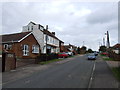
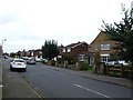
The Broadway, Minster
Not impressively broad, but certainly very straight for most of its length.
Image: © Robin Webster
Taken: 16 May 2018
0.15 miles
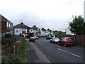
8
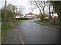
Sheppey Light Railway: Site of the former Scrapsgate crossing
The Sheppey Light Railway ran from Queenborough to Leysdown-on-Sea. It was built to the designs of the renowned light railway engineer, Colonel Fred Holman Stephens, and was opened in 1901. Traffic was never busy on the line and it was taken over by the South Eastern and Chatham Railway in 1905, finally closing in 1950.
The photographer is uncertain as to whether the crossing was made by a bridge or a level crossing, and the situation is not helped by the fact that the Ordnance Survey large scale maps available online either show the railway as working and the road as a track before the houses were built (1933), or the railway dismantled but with the houses built and the road formalized (1965).
Image: © Nigel Cox
Taken: 24 Nov 2013
0.16 miles