IMAGES TAKEN NEAR TO
Vincent Gardens, SHEERNESS, ME12 1XT
Introduction
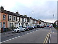
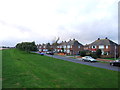
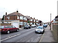
This page details the photographs taken nearby to Vincent Gardens, ME12 1XT by members of the Geograph project.
The Geograph project started in 2005 with the aim of publishing, organising and preserving representative images for every square kilometre of Great Britain, Ireland and the Isle of Man.

There are currently over 7.5m images from over14,400 individuals and you can help contribute to the project by visiting https://www.geograph.org.uk
Image Map
Images are licensed for reuse under creativecommons.org/licenses/by-sa/2.0
Notes
- Clicking on the map will re-center to the selected point.
- The higher the marker number, the further away the image location is from the centre of the postcode.
Image Listing (35 Images Found)
Images are licensed for reuse under creativecommons.org/licenses/by-sa/2.0
Image
Details
Distance
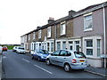
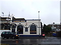
3
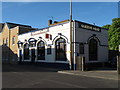
The Queen's Head Public House, Sheerness
On 282 High Street, opposite Vincent Gardens road.
Image: © David Anstiss
Taken: 26 Apr 2009
0.10 miles
5
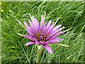
Salsify, Tragopogon porrifolius
By the path along the Queenborough Lines. An introduced Mediterranean plant, 'mostly by lower Thames' according to my flower book.
Image: © Robin Webster
Taken: 16 May 2018
0.11 miles