IMAGES TAKEN NEAR TO
Clarence Row, SHEERNESS, ME12 1RD
Introduction
This page details the photographs taken nearby to Clarence Row, ME12 1RD by members of the Geograph project.
The Geograph project started in 2005 with the aim of publishing, organising and preserving representative images for every square kilometre of Great Britain, Ireland and the Isle of Man.

There are currently over 7.5m images from over14,400 individuals and you can help contribute to the project by visiting https://www.geograph.org.uk
Image Map
Images are licensed for reuse under creativecommons.org/licenses/by-sa/2.0
Notes
- Clicking on the map will re-center to the selected point.
- The higher the marker number, the further away the image location is from the centre of the postcode.
Image Listing (197 Images Found)
Images are licensed for reuse under creativecommons.org/licenses/by-sa/2.0
Image
Details
Distance
3
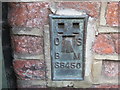
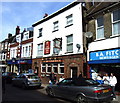
Ordnance Survey Flush Bracket S6450
This can be found on the roadside wall of a building in High Street, Sheerness.
For more detail see : http://www.bench-marks.org.uk/bm16116
Image: © Peter Wood
Taken: 12 Feb 2016
0.03 miles
6

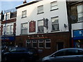
Benchmark on #46 High Street
Ordnance Survey flush bracket serial number S6450 described on the Bench Mark Database at http://www.bench-marks.org.uk/bm16116
Image: © Roger Templeman
Taken: 21 Aug 2010
0.04 miles
7
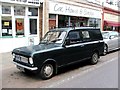
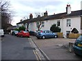
Vintage 1965 Bedford HA, High Street, Sheerness
Image: © Chris Whippet
Taken: 1 Apr 2015
0.04 miles

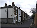
10
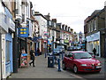
High Street, Sheerness
Looking south-eastward.
Image: © Peter Wood
Taken: 12 Feb 2016
0.04 miles