IMAGES TAKEN NEAR TO
New Road, SHEERNESS, ME12 1NB
Introduction
This page details the photographs taken nearby to New Road, ME12 1NB by members of the Geograph project.
The Geograph project started in 2005 with the aim of publishing, organising and preserving representative images for every square kilometre of Great Britain, Ireland and the Isle of Man.

There are currently over 7.5m images from over14,400 individuals and you can help contribute to the project by visiting https://www.geograph.org.uk
Image Map
Images are licensed for reuse under creativecommons.org/licenses/by-sa/2.0
Notes
- Clicking on the map will re-center to the selected point.
- The higher the marker number, the further away the image location is from the centre of the postcode.
Image Listing (15 Images Found)
Images are licensed for reuse under creativecommons.org/licenses/by-sa/2.0
Image
Details
Distance
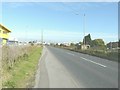
1
A249 Brielle Way
Heading for Sheerness.
Image: © Robin Webster
Taken: 16 May 2018
0.09 miles
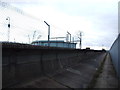
2
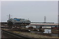
Brielle Way (A249)
On the right is a plate-layers' hut, situated beside the Sheerness to Sittingbourne railway line, which runs parallel to the road at this point. In the distance are the buildings of Thamesteel, which voluntarily entered administration on 25 January 2012 several weeks after halting production at its plant. Around 350 workers were made redundant as a result of the move with just 50 kept on to maintain the plant. On 8 June 2012, it was announced that Thamesteel had been sold out of administration to a new company owned by Al-Tuwairqi Group (ATG), joint administrators for the Sheerness steel producer http://processengineering.theengineer.co.uk/sheerness-steel-plant-to-restart-as-thamesteel-exits-administration/1012865.article See https://www.bcd-urbex.com/thamesteel-steel-works-sheerness-uk/ for a history of the site.
Image: © John Baker
Taken: 7 Oct 2012
0.09 miles
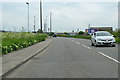
4
Brielle Way, Sheerness
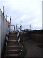
The coast path joins the road here. The railway can be seen taking a sharp right turn towards the station.
Image: © Robert Eva
Taken: 4 Mar 2017
0.16 miles
5
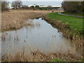
Remains of The Fleet, Sheerness
Old maps show that this drainage ditch to the south of Sheerness at West Minster linked up with the Medway Estuary to the west. It is known as The Fleet and is followed here by a path. West of the railway and the A249 it is covered in and to the north-east its former line is followed by Fleet Avenue.
Image: © Marathon
Taken: 4 Feb 2017
0.17 miles
6
Path alongside The Fleet
Old maps show that the drainage ditch to the south of Sheerness at West Minster known as The Fleet linked up with the Medway Estuary to the west. It is followed here by this path. West of the railway and the A249 it is covered in and to the north-east its former line is followed by Fleet Avenue. For the view of The Fleet see
Image: © Marathon
Taken: 4 Feb 2017
0.19 miles
8
New Cars
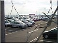
It sometimes seems that every spare square metre around Sheerness docks is covered in brand new cars.
Image: © Penny Mayes
Taken: 16 Apr 2005
0.20 miles