IMAGES TAKEN NEAR TO
Alder Close, SHEERNESS, ME12 1JW
Introduction
This page details the photographs taken nearby to Alder Close, ME12 1JW by members of the Geograph project.
The Geograph project started in 2005 with the aim of publishing, organising and preserving representative images for every square kilometre of Great Britain, Ireland and the Isle of Man.

There are currently over 7.5m images from over14,400 individuals and you can help contribute to the project by visiting https://www.geograph.org.uk
Image Map
Images are licensed for reuse under creativecommons.org/licenses/by-sa/2.0
Notes
- Clicking on the map will re-center to the selected point.
- The higher the marker number, the further away the image location is from the centre of the postcode.
Image Listing (17 Images Found)
Images are licensed for reuse under creativecommons.org/licenses/by-sa/2.0
Image
Details
Distance
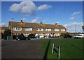
1
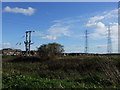
Pylons on Diggs Marshes, near West Minster
Image: © Chris Whippet
Taken: 3 Nov 2013
0.05 miles
10
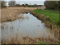
Remains of The Fleet, Sheerness
Old maps show that this drainage ditch to the south of Sheerness at West Minster linked up with the Medway Estuary to the west. It is known as The Fleet and is followed here by a path. West of the railway and the A249 it is covered in and to the north-east its former line is followed by Fleet Avenue.
Image: © Marathon
Taken: 4 Feb 2017
0.21 miles