IMAGES TAKEN NEAR TO
Mile Town Industrial Park, Grace Road, SHEERNESS, ME12 1HB
Introduction
This page details the photographs taken nearby to Mile Town Industrial Park, Grace Road, ME12 1HB by members of the Geograph project.
The Geograph project started in 2005 with the aim of publishing, organising and preserving representative images for every square kilometre of Great Britain, Ireland and the Isle of Man.

There are currently over 7.5m images from over14,400 individuals and you can help contribute to the project by visiting https://www.geograph.org.uk
Image Map
Images are licensed for reuse under creativecommons.org/licenses/by-sa/2.0
Notes
- Clicking on the map will re-center to the selected point.
- The higher the marker number, the further away the image location is from the centre of the postcode.
Image Listing (39 Images Found)
Images are licensed for reuse under creativecommons.org/licenses/by-sa/2.0
Image
Details
Distance
1
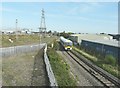
Passenger train from Sheerness
Approaching the footbridge, over the line, where I was standing. To the train's left are some of the overgrown railway tracks of the Thamesteel site. The company voluntarily entered administration on 25 January 2012 several weeks after halting production at its plant. Around 350 workers were made redundant as a result of the move with just 50 kept on to maintain the plant. On 8 June 2012, it was announced that Thamesteel had been sold out of administration to a new company owned by Al-Tuwairqi Group (ATG), joint administrators for the Sheerness steel producer http://processengineering.theengineer.co.uk/sheerness-steel-plant-to-restart-as-thamesteel-exits-administration/1012865.article See https://www.bcd-urbex.com/thamesteel-steel-works-sheerness-uk/ for a history of the site.
Image: © John Baker
Taken: 7 Oct 2012
0.03 miles
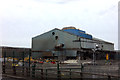
3
Former Thamesteel Site, Brielle Way
Planning permission was granted by Swale Borough Council under application number 16/501726/FULL for “change of use from B2 industrial use in the form of redundant steelworks to port related uses (sui generis) including demolition of buildings (except for the former military hospital, former fitness centre, former billet packing building, former stores and stores maintenance building and part of main former Thamesteel building), construction of new paved surfaces and a new vehicle access and bridge spanning the A249 to the existing port to the west, reconfiguration of railhead, boundary treatment and landscaping and associated works”.
This image shows this part of the Image almost a year ago. It has since become a Image
Image: © John Baker
Taken: 3 Oct 2017
0.05 miles
4
The Thamesteel site
As seen from a footbridge over the Sheerness to Sittingbourne railway line. Thamesteel voluntarily entered administration on 25 January 2012 several weeks after halting production at its plant. Around 350 workers were made redundant as a result of the move with just 50 kept on to maintain the plant. On 8 June 2012, it was announced that Thamesteel had been sold out of administration to a new company owned by Al-Tuwairqi Group (ATG), joint administrators for the Sheerness steel producer http://processengineering.theengineer.co.uk/sheerness-steel-plant-to-restart-as-thamesteel-exits-administration/1012865.article See https://www.bcd-urbex.com/thamesteel-steel-works-sheerness-uk/ for a history of the site.
Image: © John Baker
Taken: 7 Oct 2012
0.06 miles
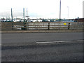
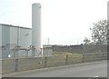
6
Former Thamesteel Site, Brielle Way
Planning permission was granted by Swale Borough Council under application number 16/501726/FULL for “change of use from B2 industrial use in the form of redundant steelworks to port related uses (sui generis) including demolition of buildings (except for the former military hospital, former fitness centre, former billet packing building, former stores and stores maintenance building and part of main former Thamesteel building), construction of new paved surfaces and a new vehicle access and bridge spanning the A249 to the existing port to the west, reconfiguration of railhead, boundary treatment and landscaping and associated works”.
Image: © John Baker
Taken: 9 Oct 2016
0.09 miles
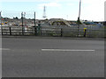
7
Former Thamesteel Site, Brielle Way
Planning permission was granted by Swale Borough Council under application number 16/501726/FULL for “change of use from B2 industrial use in the form of redundant steelworks to port related uses (sui generis) including demolition of buildings (except for the former military hospital, former fitness centre, former billet packing building, former stores and stores maintenance building and part of main former Thamesteel building), construction of new paved surfaces and a new vehicle access and bridge spanning the A249 to the existing port to the west, reconfiguration of railhead, boundary treatment and landscaping and associated works”.
The Image have been lifted and the building has been demolished. Now there is an uninterrupted view of the electricity pylon.
Image: © John Baker
Taken: 9 Oct 2016
0.10 miles
8
Disused railway tracks on Thamesteel site
Looking across Brielle Way. Thamesteel voluntarily entered administration on 25 January 2012 several weeks after halting production at its plant. Around 350 workers were made redundant as a result of the move with just 50 kept on to maintain the plant. On 8 June 2012, it was announced that Thamesteel had been sold out of administration to a new company owned by Al-Tuwairqi Group (ATG), joint administrators for the Sheerness steel producer http://processengineering.theengineer.co.uk/sheerness-steel-plant-to-restart-as-thamesteel-exits-administration/1012865.article See https://www.bcd-urbex.com/thamesteel-steel-works-sheerness-uk/ for a history of the site.
Image: © John Baker
Taken: 7 Oct 2012
0.11 miles
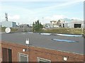
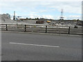
9
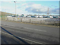
Vehicle holding area
The area is adjacent to the embankment of the Image, which was built to allow access to the existing port to the west.
Image: © John Baker
Taken: 2 Dec 2018
0.11 miles
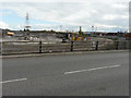
10
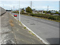
Development site, Brielle Way
On the other side of the road, the ground has been divided up, with lengths of white polythene attached to wooden posts. This could indicate that the site is going to be developed sometime in the future.
Image: © John Baker
Taken: 9 Oct 2016
0.11 miles