IMAGES TAKEN NEAR TO
Nore Close, SHEERNESS, ME12 1DD
Introduction
This page details the photographs taken nearby to Nore Close, ME12 1DD by members of the Geograph project.
The Geograph project started in 2005 with the aim of publishing, organising and preserving representative images for every square kilometre of Great Britain, Ireland and the Isle of Man.

There are currently over 7.5m images from over14,400 individuals and you can help contribute to the project by visiting https://www.geograph.org.uk
Image Map
Images are licensed for reuse under creativecommons.org/licenses/by-sa/2.0
Notes
- Clicking on the map will re-center to the selected point.
- The higher the marker number, the further away the image location is from the centre of the postcode.
Image Listing (91 Images Found)
Images are licensed for reuse under creativecommons.org/licenses/by-sa/2.0
Image
Details
Distance
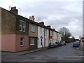
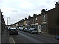
1

The Nore Public House
On St George's Avenue, near Nore Close.
Image: © David Anstiss
Taken: 22 Oct 2008
0.08 miles
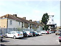
2
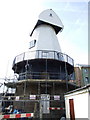
Sheerness Windmill
Approaching completion after being rebuilt following a fire.
Image: © Chris Whippet
Taken: 6 Apr 2010
0.08 miles

4
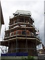
Sheerness Windmill
The replica windmill at Sheerness. Built on the surviving base of the original mill.
Image: © Michael Roots
Taken: 25 Jun 2008
0.10 miles
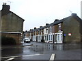
8
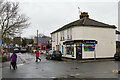
Corner Shop, Sheerness-on-Sea
At the junction of Granville Road and Rose Street.
Image: © Mark Anderson
Taken: 19 Dec 2022
0.14 miles
9
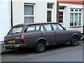
Vintage 1979 Morris Marina, Rose Street, Sheerness
Image: © Chris Whippet
Taken: 1 Apr 2015
0.14 miles