IMAGES TAKEN NEAR TO
Spritsail Way, ME1 1NR
Introduction
This page details the photographs taken nearby to Spritsail Way, ME1 1NR by members of the Geograph project.
The Geograph project started in 2005 with the aim of publishing, organising and preserving representative images for every square kilometre of Great Britain, Ireland and the Isle of Man.

There are currently over 7.5m images from over14,400 individuals and you can help contribute to the project by visiting https://www.geograph.org.uk
Image Map
Images are licensed for reuse under creativecommons.org/licenses/by-sa/2.0
Notes
- Clicking on the map will re-center to the selected point.
- The higher the marker number, the further away the image location is from the centre of the postcode.
Image Listing (536 Images Found)
Images are licensed for reuse under creativecommons.org/licenses/by-sa/2.0
Image
Details
Distance
1
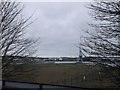
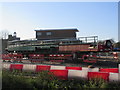
Rochester Riverside and River Medway
As seen from the platform at Rochester Station.
Looking over the development ground and Image
Image: © David Anstiss
Taken: 9 Dec 2012
0.01 miles
3
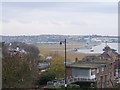
Rochester Riverside and Station from Fort Pitt Hill
Shows new riverside walk and large area for redevelopment after 'credit crunch 2008' is over and building can start again.
Image: © David Anstiss
Taken: 30 Nov 2008
0.05 miles
5
Javelin train over Blue Boar Lane railway bridge
This bridge is another access point to Medway Council's new Rochester Riverside Walk from Rochester. Rochester Riverside is a new development area north-east of railway. The javelin train (high speed) on the railway comes from London/Strood on right, heading towards Rochester/Chatham on left.
Compare with Image
Image: © David Anstiss
Taken: 12 Nov 2010
0.07 miles
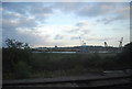
6
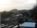
Railway line between Rochester and Chatham
As seen from the end of Platform 1 of Rochester Railway Station.
The train is heading to the station from Chatham, then to head towards London.
In the background on the hill is the University of Creative Arts
Image: © David Anstiss
Taken: 16 Dec 2015
0.07 miles
7
Parts of the new Rochester railway station
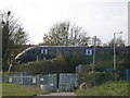
As seen from Rochester Riverside, looking across the railway storage compound.
Unsure what the part is ? Bridge or something else.
In the background is a signal box.
Image: © David Anstiss
Taken: 6 Dec 2014
0.07 miles
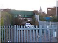
8
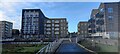
Housing on Cory's Road
As seen from the riverside path beside Common Creek Wharf.
These buildings have been built on a former Industrial wharf area, which is being converted into housing blocks.
A wharf (on the River Medway) is on the left, but at low tide is full of seaweed.
Image: © David Anstiss
Taken: 20 Dec 2022
0.07 miles
9
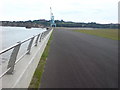
Rochester Riverside
This is a newly opened riverside path. The greened area will be built upon, there are plans for a hotel, restaurants and a lot of residential units. The land had formerly been industrial.
Image: © Danny P Robinson
Taken: 13 Jun 2008
0.08 miles
10
Railway bridge over Blue Boar Lane, Rochester
Another access point to Medway Council's new Rochester Riverside Walk.
New development area north-east of railway.
Rochester Cathedral in background.
Railway comes from London/Strood on right, heading towards Rochester/Chatham on left.
Image: © David Anstiss
Taken: 11 Nov 2008
0.08 miles