IMAGES TAKEN NEAR TO
Sunset Terrace, First Avenue, QUEENBOROUGH, ME11 5JG
Introduction
This page details the photographs taken nearby to Sunset Terrace, First Avenue, ME11 5JG by members of the Geograph project.
The Geograph project started in 2005 with the aim of publishing, organising and preserving representative images for every square kilometre of Great Britain, Ireland and the Isle of Man.

There are currently over 7.5m images from over14,400 individuals and you can help contribute to the project by visiting https://www.geograph.org.uk
Image Map (Loading...)


Getting Data...Please wait
Leaflet Map data © OpenStreetMap
Images are licensed for reuse under creativecommons.org/licenses/by-sa/2.0
Notes
- Clicking on the map will re-center to the selected point.
- The higher the marker number, the further away the image location is from the centre of the postcode.
Image Listing (66 Images Found)
Images are licensed for reuse under creativecommons.org/licenses/by-sa/2.0
Image
Details
Distance
1
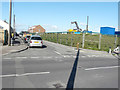
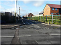
Construction site, Rushenden Road
The Image has been removed and this image shows some of the equipment in use for the redevelopment of the site, which is to be known as Nelson Vue.
Planning permission was granted by Swale Borough Council under application number 16/507298/FULL for “phase 1 of the redevelopment of land off Rushenden Road, comprising 101 dwellings and associated access, parking and landscaping”.
Image: © John Baker
Taken: 3 Oct 2017
0.03 miles
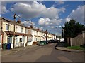
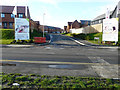
4
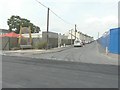
First Avenue
The Image has been replaced by some of the new houses, which have been built on a development called Nelson Vue.
Image: © John Baker
Taken: 2 Dec 2018
0.04 miles
5
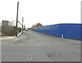
Blue hoarding along First Avenue
The hoarding hides a building site. Planning permission was granted by Swale Borough Council under application number 16/507298/FULL for “phase 1 of the redevelopment of land off Rushenden Road, comprising 101 dwellings and associated access, parking and landscaping”.
Image: © John Baker
Taken: 29 Sep 2013
0.04 miles
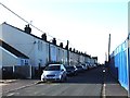
6
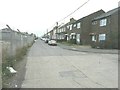
First Avenue, Rushenden
As seen from the junction with Well Road. Most of the buildings along this road were encased in scaffolding to enable cavity wall installation.
Image: © John Baker
Taken: 8 Jan 2012
0.05 miles
7
Ladybirds Children?s Centre, First Avenue
It was reported in the Kent and Sussex Courier on 19 November 2011 that seven prefabricated pieces had been delivered on 10 November to the site for eventual assembly http://www.courier.co.uk/Ladybird-centre-s-new-home-flies/story-11999546-detail/story.html Last September, the centre was described in Image
Image: © John Baker
Taken: 27 Jul 2014
0.05 miles
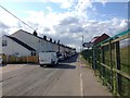
8
Flanagan Avenue
The access road into a development called Nelson Vue.
Image: © John Baker
Taken: 2 Dec 2018
0.06 miles
9
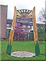
Welcome to Rushenden
This cheerful sign is possibly the most attractive feature of this grid square.
Image: © Richard Dorrell
Taken: 9 Mar 2008
0.06 miles