IMAGES TAKEN NEAR TO
Rushenden Road, QUEENBOROUGH, ME11 5HB
Introduction
This page details the photographs taken nearby to Rushenden Road, ME11 5HB by members of the Geograph project.
The Geograph project started in 2005 with the aim of publishing, organising and preserving representative images for every square kilometre of Great Britain, Ireland and the Isle of Man.

There are currently over 7.5m images from over14,400 individuals and you can help contribute to the project by visiting https://www.geograph.org.uk
Image Map
Images are licensed for reuse under creativecommons.org/licenses/by-sa/2.0
Notes
- Clicking on the map will re-center to the selected point.
- The higher the marker number, the further away the image location is from the centre of the postcode.
Image Listing (135 Images Found)
Images are licensed for reuse under creativecommons.org/licenses/by-sa/2.0
Image
Details
Distance
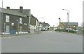
1
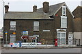
Queenborough. Rushenden Road from Main Road
Image: © Robert Eva
Taken: 4 Mar 2017
0.01 miles
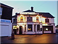
2
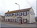
The Trafalgar Hotel
Standing in Rushenden Road near its junction with Main Road. I can think of more attractive locations to stay...
Image: © Richard Dorrell
Taken: 9 Mar 2008
0.02 miles
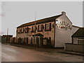
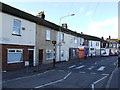
5
Railway Terrace, Queenborough
As seen from its junction with Rushenden Road
Image: © John Baker
Taken: 8 Jan 2012
0.02 miles
8
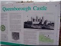
Queenborough Castle sign
This sign shows a drawing of Queenborough Castle in circa 1610. The castle was built some 300 years earlier. The sign is located at the site of the castle, though there are no visible remains today.
Image: © Richard Dorrell
Taken: 9 Mar 2008
0.04 miles
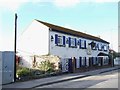
9
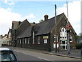
Queenborough Library
On Railway Terrace. Was a former Elementary Public School.
Image: © David Anstiss
Taken: 26 Apr 2009
0.05 miles
10
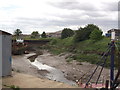
Queenborough Creek
This creek flows from the Swale into Queenborough Harbour, then after the dam in the background it becomes a meandering river (or drain - on maps) towards Neatscourt Marshes.
The dam helps the river become deep enough for fishing boats to use at high tides.
Image: © David Anstiss
Taken: 9 Jun 2012
0.05 miles